Friday, June 23, 2023

THE INCOMPREHENSIBLE BEAUTY OF DILAM, CALAYAN

"THE INCOMPREHENSIBLE BEAUTY OF DILAM, CALAYAN"

By Saniboy Pacursa

CALAYAN, CAGAYAN | A galaxy of islands spattered the Philippine territory straddling just above the equator where tropical climate zone rules nearly a third of the world's coastlines. Tropical wet season prevails here where the Philippines lies; where trade winds from north and south of the equator converge, creating a notorious barrage of typhoons. These rotating winds, often, but not always, follow familiar tracks. Typhoons moving westward from the Mariana Islands have often battered the country, rendering the Babuyan Group of Islands north of Luzon one of the most usually devastated.

Calayan Island is part of the Babuyan Group of Islands that also comprises the other major adjacent islands of Babuyan, Dalupiri, Camiguin and Fuga; all administratively under the jurisdiction of the island municipality of Calayan, except for Fuga which is politically controlled by Aparri.

One of the islands called Calayan is a clichΓ© of a tropical paradise evoking a coastal realm that is barely attainable...

Sibang Cove, Calayan Island's most iconic spot

But clearly, change has come to this once barely attainable paradise as Calayan now can be more conveniently accessible with the introduction of more stable ships and fast planes to supplement the often cumbersome, old-school rigger boats called "lampitaw".

Truly that every summer, tourism industry is now seeking Calayan's glass-clear waters, pristine white beaches and its grandiose land-seascape incomparable to anywhere else. But thrill-seekers mostly end up into the south-southeast portion of the island at Nagudungan Hills and Sibang Cove, though still both are the most iconic representations of Calayan's perplexing charm.

But Calayan is more than just the developed and well-known Sibang and Nagudungan...

A view of Nagudungan Hills from the sea

In the far, wilder north of the island called Dilam, is a realm that offers an impressive, often contradictory variety of landscapes: boulder black and white beaches, dense forests and open grasslands, rocky coasts and hilly terrains, deep waters and shallow tidal flats. 

Shifting my adventures to the more remote, I focused my sight to the coastal village of Dilam sequestered between the tropical rainforest vicinity of Mount Calayan, the island's loftiest and the ever-hostile Balintang Channel, north of the island. This massive body of water geographically unlinks Babuyan Group of Islands to the Batanes Group of Islands. I've got this journey to this dream land where time seemed to have stood still. Few outsiders have reached this paradisiacal place. Until just few years ago, Dilam was a silent, hardly known, sparsely populated spot where locals had a monopoly of the rich fishing grounds and stunning views of the wild shores and the white beaches and everyone was just worried about their immense catch. Very recently with the opening of Calayan Airport, there was an exodus of mass travelers especially during the peak of this summer and even though it has begun to open its ports to the hungry outsiders, Dilam remains somehow undisturbed, special and unique but beckoning every traveler with the enchantment of the remote, the barely attainable.

One of the many pristine white beach in Dilam

Located on the peninsular northeast of Calayan, Dilam is the second largest barangay of this island municipality in terms of land area next only to Cabudadan but the former has the longest coastline among the seven barangays found on the island. Close to 2,000 people inhabit the village who constantly prowl the bounty of the sea for a living. I say it again, Dilam is still unknown to man but here is where most of the fresh catch of the island are sourced, eventually making their way to the Luzon mainland as far as Claveria, Aparri and Santa Ana, Cagayan.

For me, the excitement of Dilam would come to its wild coast dotted with massive rock formations and fine, coraline white beach alike, and its rolling, verdant pastoral beauty. But it would be as much in a medley of small delights that please my senses: the warmth of the welcoming Calayano or Calayana locals, the taste of an exotic island fruit called "sida-i", the scent of the morning sea breeze along the pristine shore, the unending barrage of surfs racing towards the tide line and the spectacle of people collecting myriad array of seafoods on the tidal flats and shallow reefs.

Tidal flats and shallow reefs rich in marine life 

My first venture was aimed at Bimmukel Hills, a vast expanse of rolling landscape in a carpet of verdant grasses strewn with rounded rocks and boulders. Grazing cattles and goats find refuge in the open fields and the potency of the air fresh from the sea creates fantasies of Batanes chronicles. Named so because of the perfect round hamburger hill that jutted out to the sea lapping its base.

The eastern portion of Dilam is a cape peninsula that forms a deep cliff projecting out to the Balintang Channel. The place called Batang, rises high from the beach where the perfect outline of Camiguin and Babuyan Islands are the scenes to behold. It requires an arduous up hike away from the Bimmukel Hills with the consolation of gasping each breath from the panorama of the spectacular entirety of the uninhabited, alien-like terrains of Dipari Island viewed on top. Arguably it was never visited by non-local tourists according to the guides but celebrities such as Yen Santos, Albert Martinez and other known politicians have landed at Batang through a helicopter.

The breath-taking view around the verdant Bimmukel Hills

At the base of the peninsula is a confined forest thickened with the entangled mass of tropical vegetation. The locals named the woodland as Pimmutipot Forest because of the bizaare characteristic of the trees with twisting or wrung branches. The name was derived from the Iluko term "putipot" which means twist. We found plant species rarely or not found on the mainland Luzon thriving here such as the bandicoot berry, mangrove apple, almaciga, magallayaw, iron wood, callophyllum, sago palm and fauna of endemic species of tarantula and weevil.

We haven't found though the elusive avian Calayan rail known as piding, a strong indication of its decline, confinement and rarity.

One of the endemic species of plants found in Calayan

Interestingly, all of the islands of Calayan are tagged by Haribon Foundation and Bird Life International as KBA or key biodiversity areas with outstanding universal value due to its geographic and biologic importance. Also, the islands have never been part of any large landmass, and thus possess unique flora and fauna, most of which are confined only to these islands.

My supposed travel to the volcanic island of Babuyan to witness the breaching of humpback whales and to purposefully summit the peak of Babuyan Claro Volcano was halted by the disturbance of weather patterns and thus, clearance from the Coast Guard didn't pursue. I found myself rather stranded in an island north of Dilam called Dipari.

The extreme weather and the unpredictable stance of the sea have robbed Dipari Island of some of its popularity but the enchantment on this uninhabited island remains as lovely as when the first sailors discovered this out-of-the-planet landscape. Masterworks of nature had sculpted giant mystifying sea stacks also called by the Calayanos as "kimmandela" or candle-like that still cast spells of beguilement to the rare spectators who come to visit them.

Several of the more than a dozen sea stacks in Dipari Island known locally as "kimmandela" or candle-like

There are more than a dozen of these towering spires staggering at different sizes and half of those are about 30 meters high or more, the tallest could possibly reach nearly 100 meters. 

These monuments serve as silent sentinels to the island located on its northern tip to which they directly face immense bodies of water called the Balintang and Bashi Channels, and to where the next major landmass to stumble is Taiwan. 

You cannot find Dipari Island on the maps but instead, it is charted in Google Maps as Panuitan Island, still roughly 8 kilometers from the nearest point of Dilam, in Batang Peninsula. The water surrounding the island is hostile and constantly into unrest mode yet, it evokes the powerful aquamarine blue of aquarium seas that harbor benison of rich marine resources.

Dipari is as dangerous as it is alluring. Its waters are deep and its shores are rocky endlessly rammed by the raging surfs of the Pacific and South China Sea. Its domain reminds me of the volcanic islands of Hawaii and its stretch of white beach, the Waikiki. We feasted on various shellfish and seafoods as strange as the chiton and abolone we previously collected in Dipari's "kadilian" or tidal flats as our gastronomic palates mutated from ordinary to exotic. 

Tidal flats made from coral beds rich in edible marine creatures 

True, much of this peculiar island remains immaculate out of reach for most tourists. Remoteness and weather remain primary defenses of this realm and it's not easy to imagine a resort on this island which has been called the wildest place in Calayan. But, though strongly defended by the weather and the sea, Dipari is slowly being attainable only by the intrepid; those who are in dire need of exploring the great outdoors, even though it took us three days to tame the sea before we could do our conquest.

My next stop was in Layag, a vast spread of pebble white beach with long and wide tidal flats and coral beds extensively teeming with crustaceans, molluscs, seaweeds and fishes. Cowrie shells, fan clams, myriad species of urchins, box crabs, sea slugs, and sea snakes to name a few and collect a handful of those edible ones for lunch is found enjoyable if you were to meet the low tide. 

The massive boulders found on the Tagipuro Island just across the Layag Beach

The so called Tagipuro Island just across the Layag Beach is actually an elevated tidal zone with a mini white beach spattered with gigantic boulders that have been incised into shapes by the wind and the sea in timeless confidence. It virtually transforms into an island during high tides since you could not see its connection into the Layag Beach.

The great white sands of Layag Beach

Westward of Layag is the equally immaculate beach of Laton, a kilometric, uninterrupted expanse of white beach that extends into Dibay, the westernmost barangay of Calayan. Magnificent rock forms resembling the sphinx, flower vase, tables, spheres and countless irregularities cloak Laton's wild coastline that lend drama to its surroundings. Defenseless against the pounding waves, these massive coral rocks crumble overtime on the weathered coast that define the outline of Dilam. From end to end, Layag and Laton Beaches when combined forms an 11-mile long white beach and tidal flats, the longest of its kind in Calayan. Between Layag and Laton is the rustic, Kannaway Cave and beach enthralling with its bluish-green waters of crystal clearness quality. How such magnificent coastline evolved to such nature marvel is a complex story of geologic forces, of ocean currents and sculpting winds.

One of the countless rock formations near Layag Beach resembling the Egyptian sphinx

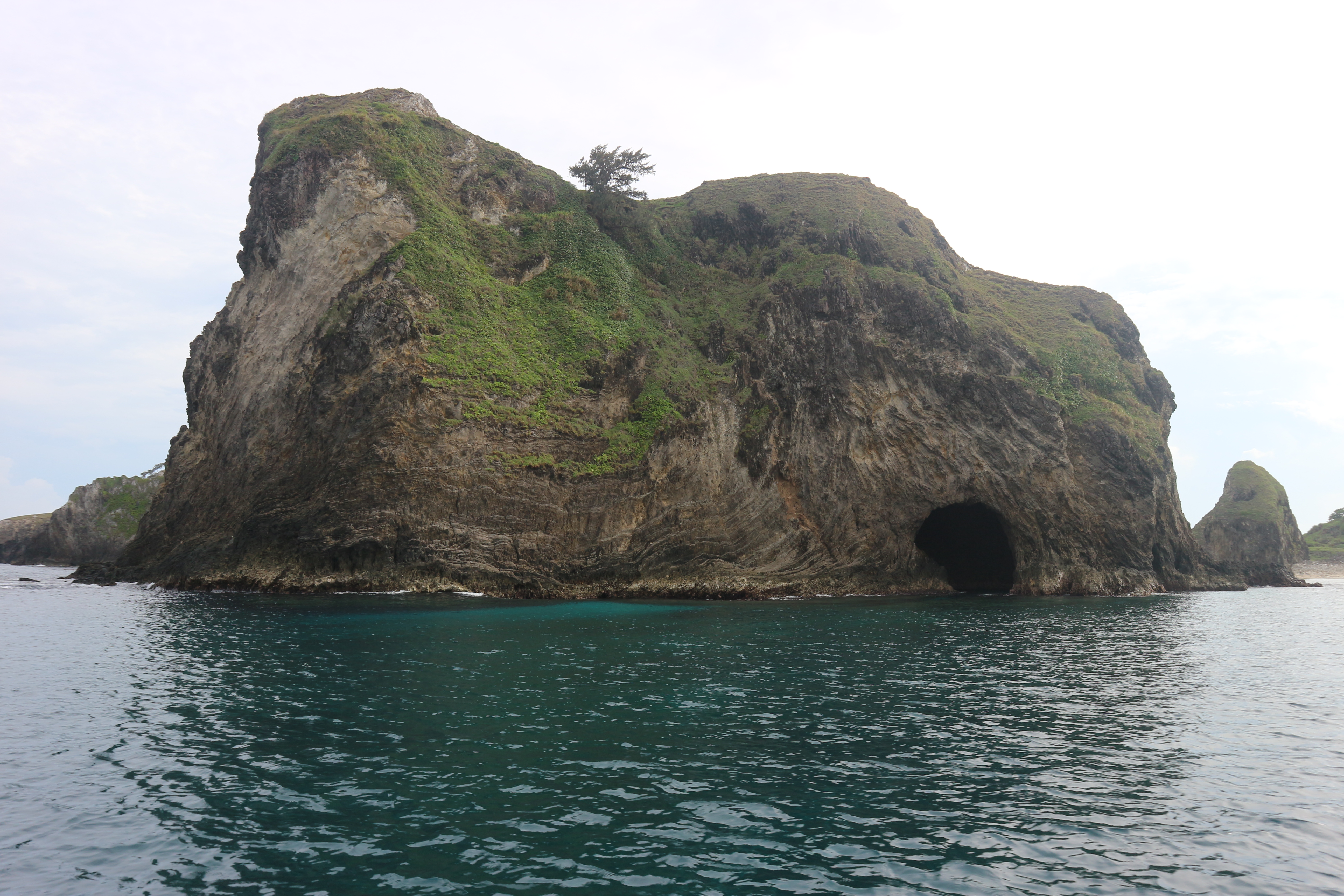
Kannaway Cave is different from the sea cavern found in Magsidel, the Lussok Cave. The latter was formed from columnar basaltic rocks while the former was conceived from limestone rocks and coral upheavals. Both though without exception, they can be a haven for snorkelers and expert swimmers.

Kannaway Cave was named from the "kannaway" birds or herons that seek sanctuary on its crest, spires and shades; those resting from the long migration going southwards as far as Candaba Swamps in Pampanga.This richness, together with those found on its deep waters and rainforests had an immense value to the natural world and to the country's biodiversity and thus, some conservationist groups wanted it declared a National Park and be enlisted into UNESCO World Heritage Site list.

The spectacular view inside the Kannaway Cave

Kannaway Cave and Beach is not for the faint-hearted, much more not for the novice for you're not dealing with an ordinary, walk-in-the-park beach or cave. You have to be exposed to the elements of the sea and fight with the tidal surges. It's no easy feat but if you do, consider yourself very lucky for you've conquered one of the splendors of Dilam whose beauty is beyond comprehension.

I might be sued if I fail to perfectly define and describe with contentment and satisfaction the medley of enchantments I discovered in Dilam. But I wanted to be clear; I have been so stupid for not getting to Dilam the first time I had my first glimpse of Calayan. All I thought the island's sheer beauty was not all beyond my comprehension but rather it was the irony.

The beauty of Dilam beyond usual comprehension 

Remembering the previous story when I wrote how the angels saw Calayan in their flight, I presumed it's possibly that they passed over Dilam too because there, scenes so lovely and wonderful these angels must have been gazed upon it on their flight in heavens - with their breaths taken away to that incomprehensible beauty of Dilam they saw first before I did.

#CalayanCagayan #VisitCagayanPH #EndlessFunCagayan #DilamCalayan #Cagayan #CagayanProvince #ExploreCagayan ##ExploreDilam #IslandLife #IntoTheWildSeries#TworismoSaLambak #YourIslandsAndValleyOfFun

Friday, May 5, 2023

NEWS UPDATE: INTER-BARANGAY DANDEX CUP TOURNAMENT - 2023

 MALINTA DESTROYS CROWD-FAVORITE TUCALAN

A balanced combination of perimeter shooting and drives to the paint proved fatal as the Malinta cagers lambasted Tucalan Passing en route to 66-54 victory during the bracket elimination round of Dandex Cup Tournament held at Natalged Court on May 4, 2023.

Malinta outscored Passing 40-24 in the first half via short stabs and penetration combo led by Carranza and Balisi, confusing the defense of the squandering Passing. 

Paculdar (center) drives to the basket while Cudal elevates trying to block the shot as Balisi (left) watches in elation.

Hot-shooting Malinta extended their lead to 16 on the early of the third canto but Passing gained their composure as Bermejo and Cudal stepped on the gas to briefly cut the lead down to just 6 near the end of the quarter bringing cheers to the elated Passing die-hard fans.

Tucalan Passing needs more of assists like this if they want to become a contender.

On the last salvo, Malinta coach Kamar Delos Santos adjusted their game plan, employing more assists that saw Paculdar, Duldulao and the bench joined the scoring spree as they silenced the crowd. Passing has never came back in the fourth after the assaults mainly from short jumpers on the wings and attacks on the shaded lane.

Biag stands his ground against the high-flying Bermejo (right) in one of the rebound plays.

Malinta held on to their lead of 12 until the end game as turnovers have afflicted Passing that doomed their very hope to draw the first blood.

Carranza was declared the best player of the game.


Wednesday, April 12, 2023

A DAYTIME ESCAPE INTO THE PENABLANCA PROTECTED LANDSCAPE AND SEASCAPE

πŸ“Œ Allahiban Viewpoint, PeΓ±ablanca, Cagayan

Largely covered by the thickness of the grandiose Sierra Madre mountains, PeΓ±ablanca is often thought as Cagayan's wildest frontier.

It is home to the province's highest peak, Mount Cetaceo and boasts some of the country's most spectacular caves and landscapes and seascapes providing a haven for high-spirited nature adventurers.

Pinacanauan River horseshoe bend known as a "meander"

PeΓ±ablanca is undoubtedly Cagayan's ecotourism capital and at the same time promoted as the caving capital of the entire Philippines owing to its more than 300 tantalizing and mighty caves that riddled its limestone mountains. Its relatively low population density, the second most sparsely-peopled municipality of Cagayan next only to the pristine island town of Calayan, and its reasonably effective conservation measures ensured the region's richness in unspoiled wild expanse. It's land area is larger than the total territories of the municipalities of Amulung, Iguig, Enrile, Tuao and Tuguegarao combined.

One of the numerous limestone karsts of PeΓ±ablanca

And so in 2003, under the recommendation of the DENR through the National Integrated Protected Areas or NIPAS, parts of the region became a Protected Landscape And Seascape. In 2018 as conservation became more accentuated, the then President Rodrigo Duterte signed into law through the Expanded National Integrated Protected Area System or ENIPAS the designation of the PeΓ±ablanca Protected Landscape and Seascape (PPLS) as a national park.

Biodiversity of PeΓ±ablanca, a green racquet tail plume

The park's landscape is dominated by dome-shaped and extremely porous karst limestone mountains dotted with intriguing caves, traversed by the snaking and clean Pinacanauan River and augmented by the sight of dense scrubby vegetation that grows undisturbed on the karsts and cliffsides of the river.

The most popular part of the PPLS however is the Callao Caves National Park, undoubtedly the Cagayan's face of tourism because of its archaeological importance; the cradle of the earliest known Filipino humans, the Homo luzonensis that far predates the Palawan's "Tabon Man".

About 20 kilometers from the city of Tuguegarao lies an underrated but a good starting point for adventures further into the almost impenetrable rainforest of PeΓ±ablanca, the largest protected forest under stringent conservation in Cagayan. Known as the Allahiban Viewpoint, it is actually a commanding vantage point on top of a limestone mountain that offers a panoramic view of the river's horseshoe bend technically termed as a "meander" that beautifully curves between massive calves of limestone cliffs almost as beautiful and raw as the prehistoric landscape before the geologic time record. 

Located in Sitio Bagabba in Brgy. Aggugaddan, one of the 18 out of 24 barangays that constitute the protected landscape and seascape of PeΓ±ablanca, the viewpoint does not seem to instill comfort and easy trek for the novice especially when it is done during day time or when the sun is already fairly high. The arduous ascent is hot and sweaty - unless you decide to take the trek at dawn up the mountain to witness the morning clouds wafting over the horseshoe bend, and those, appear much lower than the top of the mist-drenched cliffs.

There is a disadvantage however if the hike is done not at daytime; you could not see the verdant surroundings and the immense ocean of greeneries that blankets the environs, the emblem of the great Sierra Madre.

The hot, almost tree-less terrain going to Allahiban Viewpoint 

But for the seasoned excursionists, the trail is generally not a difficult undertaking for an easy one hour stroll to a dusty track and to where you could only see rather short, shrubby vegetation that cannot offer cool shades at all. It is the heat that exhausts hikers up, and the razor-sharp saccharum grasses (talahib) and thorny vines that bring nuisance and discomfort to the thirsty climbers. 

On the top however, the length of the bending meander drives the spectators crazy with the eye-pleasant, dazzling river-forest-landscape that defines the grandeur of PeΓ±ablanca apart from its enigmatic caves. From the viewpoint and across the river, a vertical limestone mountain stands mightily above all, resembing a plateau, evoking the majesty of the Table Mountain of South Africa, one of the Seven Wonders of Nature; a scene that truly remained unchanged for millennia.

One panoramic portion of the immaculate, clean river 

The Pinacanauan river is a clean body of water that sashed the white rocky landscape of PeΓ±ablanca, providing a water source downstream to Tuguegarao City. As the calcite (CaCO³) embedded on rocks dissolves in the river, the corrosive acidity of water is reduced, raising its pH and also purifying the water. To where the river emanates is the thick tangle of primeval tropical rainforest of PeΓ±ablanca, known home of Cagayan mega fauna such as the vulnerable Philippine deer (ugsa), Philippine crocodile (bukkarot), Sierra Madre shrew (sangyo) Malay civet (mutit, musang) green racquet tail, and the endangered Philippine eagle. The Isabela oriole (Oriolus isabellae), a vivid yellow bird (kilyawan) previously tagged as extinct for many years has perplexed ornithologists from Mabuwaya Foundation, a conservationist group working for endemic and endangered Philippine species when they recorded sightings of the bird thriving in Sierra Madre particularly in Baggao and PeΓ±ablanca. The discovery testifies the nurturing capacity of the northern Sierra Madre to take refuge flora and fauna species in severe distress.

Scrubs and bushes dominate the early parts of the trail going up to the Allahiban viewpoint

From the giant karst across the horseshoe bend, is the visible entrance to the Bat Cave named so for the amazing spectacle of million bats in their daily, synchronized circadian flight that occurs at dusk in search of food while the nearby Callao Caves eco-tourism zone lies northwest of the bend and is very accessible from Brgy. Quibal with ease.

Up to Allahiban Viewpoint, grasses and shrubs dominate the jagged trails made up of limestones giving clear visibility of the open, vast 360 degrees panorama of the surroundings: the immense corn and rice fields of Lagum on the east, the village and the flatlands of Aggugadda on the west, and from north to south is the immensity of tropical greeneries that was cut in the middle by the Pinacanauan river.

Below is an extensive band of riverine bushes that lined the riverbanks and an impervious tangle of vines, stunted and gnarled trees and bushes, wild flowers and ferns obscure the precipitous section of the cliff face from top to bottom. This obscurity allows the viewer to stand fearlessly on a ledge near the cliff edge, generally fooling first-time visitors into believing that the point to where they stood is not high, rather than the less visible, hidden 200-meter deep chasm that awaits in disgrace the uncareful and negligent. 

The upper right portion of the limestone mountain where Callao Caves are located

At the basal rock located at the bottom of the cliff called a "pediment" are thick vegetations thriving on the wetness and relatively abundant water as it sits rightly at the edge of the river. On the cliff face however, virtually contains no soil at all and as stated, only long-lived plants and bushes eke out a living by attaching their roots to the holes and gashes found on the very steep cliff face.

The Allahiban vegetation is very sparse since the level and slightly rounded top of the cliff called a "bluff", is extremely dry and excessively drained as it cannot hold enough water. The soil there is very thin where only perennial plants grow adaptively. But the bluff overlooking the body of water on the outside of a stream meander makes up more than enough of the stunning sight below than its bleak, grassy summit devoid of broadleaf trees.

These descriptions woven together, make for a fascinating visit to PeΓ±ablanca, literally translated to "white rock". These massive glistening limestone rocks that embody the central pillar of the protected landscape and seascape could be the first icon the Spaniards saw upon forming their bastion on this now first-class municipality that was once a village of the old Tuguegarao.

The Lord God made them all

And to sum it up, PeΓ±ablanca is not just about the Callao Caves. Focusing in just one part of a place that is well-known and what is being advertised is absolutely not extraordinary. You have to discover more, shoot the angles less photographed, trek the path less traveled and don't just follow trails. Make them. And along the bumpy, scraggy road you take, you'll find the beauty of the immaculate river, the primordial landscape, the azure sea, the formidable jungles and the bright sky; all are part of what makes PeΓ±ablanca and the rest of the planet an extraordinary and exciting place to explore.

Video:

https://fb.watch/jDIdxJmx8s/

---

"God made all things beautiful in His time and he put the world in man's heart so that they cannot measure God's creation from beginning to the end.

I know there is no better in man than for them to be happy and do good while living, and also, that, every man should eat, drink and enjoy the fruits of his labour, which are the gifts coming from God".

Ecclesiastes 3:11-13

#VisitCagayanPH #EndlessFunCagayan #Cagayan #CagayanProvince #IntoTheWildSeries #Tworismosalambak #PinacanauanRiver #PeΓ±ablanca #AllahibanViewpoint #SierraMadre

Wednesday, February 15, 2023

CALAYAN ISLAND: HOW THE ANGELS CALLED IT A PARADISE BARELY ATTAINED

SUMMER SPECIAL:

THE 25 THINGS YOU MUST DO IN CALAYAN ISLAND

PROLOGUE:

"But for the angels who had the first glimpse of the wonderful and lovely Calayan, they must have thought it would be better, if it remained that way; far from the molesting touch, a paradise barely attained".

CALAYAN ISLAND: HOW THE ANGELS CALLED IT A PARADISE BARELY ATTAINED

πŸ“Œ Calayan, Cagayan, Philippines 

When the first Chinese sailed in silence to every corner in the expanse of the South China sea some 2,000 years ago, they might have passed upon the islands of the tranquil Babuyanes. They might not landed and established settlements because the scattered Babuyan Group of Islands appeared to them as barren and windswept at eye level. But when these Chinese sailors died and became angels and about to fly, in one of the islands called Calayan, scenes so wonderful and lovely these angels must have been gazed upon it on their flight in the heavens.

A view of one of the white sand coves of Calayan

Calayan is one of the islands of the Babuyan Group forming an almost perfect circular archipelago with the other major islands north of Luzon and is the only island municipality of Cagayan province.

The Babuyan Group of Islands consisting the primary islands of Calayan, Fuga, Babuyan, Camiguin and Dalupiri and its smaller islands and rocks is the ultimate "group of islands adventure" the full-blooded explorer could get, so much that reaching these paradise requires a gamble against the treacherous, unruly waters of the Babuyan and Balintang channels. But there is a reward to every bravery; a spectacle of breaching humpback whales, friendly pods of dolphins racing against the surfs and schools of anchovies (munamon) in millions along the way to the so called the "playground of the giants".

Calayan is the largest of the rest of the islands in the Babuyanes. It administratively controls the other inhabited islands mentioned except Fuga which is under the jurisdiction of the municipality of Aparri.

Sibang Cove, the most pristine cove in the island of Calayan

Calayan is just a recent nature adventure discovery as most people don't wander that far up north as its isolation runs into one of the sharpest extremes in the country; a paradise barely conquerable and attainable.

The island itself speaks to the myth of the Babuyanes; an eternal wave-barraged rocky shores edged by aquarium clear seas. And beneath the torrential waves are bounties and the fulfillment of our imaginings of tropical coastal wilds jewelled with colors of teeming life forms. Above the torpedoing surfs, it evokes the idyllic rolling hills comparable but unique to Batanes, the Nagudungan Hills, arguably one of the most breath-taking if not the most perfect landscape-seascape in the country.

The edge of Nagudungan Hills facing the enormous Pacific

As we watched the slow march of the sun across the sky, I felt the sting of white sand over my face as the cool wind of the Pacific playfully blasted the turquoise-bluish green waters of the iconic Sibang Cove. Being the most prominent defining glory of Calayan Island, the finest, revered white-sands of the cove transform golden cream upon contact with the foamy, azure waters of the sea in a backdrop of coral limestone hills surrounded by tropical greeneries that foster and sustain the endemic flightless bird Calayan rail (Gallirallus calayanensis), never could be seen anywhere else on the planet; another testification of how rich the Philippine tropical forests in terms of wildlife inventory.

The wild coast of Magsidel and Dibay, southwestern part of the Calayan Island 

Sibang is trapped between the pristine coves of Caniwara and Cababaan, each have different taste of offerings that mingles well with each type of traveler-adventurers. If one has to boast Instagrammable clicks, swim with the unpredictable current - sometimes gentle, sometimes untamed, or just lie on the pandanus-covered inland shore, you must choose Sibang Cove. If marine biology is your stuff, you got a penchant in extraordinary sea creatures or you're brave enough to snorkel its deep, these excitements can be found west of Sibang, in Caniwara Cove with its immense shallow tidal flat zones and coral beds refuging myriads of species; brittle stars, sand dollars, sea cucumbers, whelk, sea weeds, fishes, different species of starfish, shellfish, urchins and other life forms too many to mention.

The most perfect view of the Caniwara Cove, southeast of the Island

Strolling eastward is the Cababaan Cove where one can commune in quiet solitude. The most unspoiled and longest of the trio white sand coves, Cababaan is truly majestically wild and purely immaculate. Its huge wave patterns and furious stance allow nature to construct its own architectural landscape designs; white rocks and boulders conceived by eons of erosion, accretion and sedimentation. It is that ferocious tendency that makes Cababaan Cove a thing to conquer.

On the far southwest coast of Calayan where the shore is defined by rocky coastal realms, one can be forgiven thinking that places called Magsidel and Dibay have been mistakenly thought to be the rugged American west coast of Oregon or Baja California. Whoever has felt the stinging wind or heard the roar and seen the concussion of angry waves crashing onto a bouldered rocky beach knows that all coasts on the planet are inherently wild.

The Kannaway and Lussok Caves are the kings to behold in the western portion of the island where the land near the shore is hardy and barren brown. But this characteristic has not taken away the bizaare beauty Calayan could possess. There are much more to see in Kannaway Cave other than its namesake which means the "great white herons" regularly flocking above it. Lussok Cave, meanwhile is translated from Ilokano dialect as "a hole". Lussok has two entrances that can only be reached through snorkeling or kayaking. A cave protruding into the pristine seas, the Lussok, like all of other terrestrial caves harbors bats and swiflets and their nests. What makes sea caverns unusual is the lack of speleothems or formations since these are not made from limestones but from columnar basaltic rocks.

One of the beaches found in the nearby island of Camiguin, part of Calayan

These are structures that formed in rocks (commonly in basalt) that consist of columns (mostly commonly hexagonal in shape) that are separated by joints or fractures in the rock that formed when the rock contracted, most often during cooling that happened in great expanse of time.

The cave is perfect for rock jumping and snorkeling onto its crystalline bluish-green waters every thalassophile could wish for.

A sea cave as colorful as a candy

The Punta de Magsidel is a frontier of rocky seascapes and Dibay a coral reef garden-laden bountiful paradise. This wide sea stretch of the island is where most of the big catches are sourced. Coral beds and reefs are shallow where different seafoods can be collected as easy as lacing your shoes. Among the rocks, sea crabs (kappi), sea mantis (palpaltik), urchins (pumapana), edible echinoderms, various shells (e.g. bulaw-bulaw) and ar-arusip (sea grapes) are what you can get from the shallow tidal flats.

The tidal pools on the rocks trap stray fishes as they may have forgotten the receding tide when they wander near the coast. Spear and arrow fishing must be a good try.

As feet go hand in hand with the palate, it's a deserving exaggeration to say that you have not been in Calayan if you haven't eaten a tasty lobster or the scrumptious spanner crab (kusimay).

The solemn water ribbon of Bataraw Falls not that far from the beach front

The rainforest of Calayan on the center of the island is an important bird sanctuary and stop-over for migratory birds flying from northern hemisphere going south as far in Candaba swamps in Pampanga. Towering above like a giant sentinel to the island is the 499-meter tall Mount Calayan, a once active but now an extinct volcano. Surrounded by verdant evergreens, the mountains are home to coots, passerines, birds of prey and the declared vulnerable by the IUCN (International Union for Conservation of Nature) - the Calayan rail which estimates are numbered to no more than 5,000 mature individuals. Below the lower canopies of the mountains, the population of the now endangered coconut crabs (tatus) once thriving and undisturbed is now dwindling into its extinction as human palates mutated from the ordinary to exotic. Not far from the mountain, the striking Bataraw Falls which its water from the mountain source flowing not too far to the sea can be found in hiding among the foliages.

Tidal pools during high tide that trap stray fishes

Defining and describing in detail the entire island's gems would be an arduous feat to make as countless scenes and stories could be imagined and turned into a reality. I could've written a book that thick if I could do so...

Going back to the angels that have gazed upon Calayan Island on their flight in the heavens, I must prove to them, and to the rest of the world that they were right when these same angels said "scenes so wonderful and lovely" pertaining to the fantabulous island they saw.

Today, clearly change has come to the paradise that was once barely conquerable and attainable to anyone. Resorts and inns now spatter its coasts and interior. Tourism is already seeking its shores every summer and conservationists warn gravely irresponsible human impact even here on Cagayan's last nature frontier.

The crystal clear waters of Lussok Sea Cave ideal for snorkeling and swimming

That's true, Calayan and all the northern islands remain pristine, tantalizingly out of reach for most mass travelers. Its remoteness, the weather and the treacherous open seas remain as the primary defenses of this paradisiacal realm. But honestly, Calayan today is less daunting to visit than 100 to 50 years ago. Its shores became more accessible as cumbersome skiffs and rafts are replaced by swift ferries and planes. Its bewildering wild coasts have been outlined, its terrains mapped, its delicate waters navigated and its forests and mountains have become more fragile than once imagined.

But for the angels who had the first glimpse of the wonderful and lovely Calayan, they must have thought it would be better if it remained that way; far from the molesting touch, a paradise barely attained.

Barred filefish locally known as "sungayan", a testimony of the richness of Calayan waters

More of Babuyanes:

https://m.facebook.com/story.php?story_fbid=2215477002038401&id=100007283687906&mibextid=Nif5oz

More of Calayan:

https://m.facebook.com/story.php?story_fbid=pfbid02crF1Ad5bB1HqmS3MfDc5yXrzefBAneDYx1EpPfkaVstjYZVnRVsfoW395YBZg2gLl&id=100007283687906&mibextid=Nif5oz

#ExploreCagayan #IntoTheWildSeries #VisitCagayanPH #EndlessFunCagayan #Cagayan #CagayanProvince

Tuesday, January 17, 2023

THE FRIGHTENING TABACO CAVE

SANTA TERESITA, CAGAYAN:
An Unexpected Geological Anomaly 

πŸ“ŒTabaco Cave, Luga, Sta. Teresita, Cagayan

In Santa Teresita, Cagayan, I had entered a geological anomaly profoundly different from places I've conquered so far - enthralling in its oddity and unexpected beauty.
Honestly, this seemingly unnoticed, tiny town was not a priority in my bucket list for this year's inventory of my "#IntoTheWildSeries" adventures. Barely heard, all I know about this silent town was a transit warp going to the paradisiacal municipality of Santa Ana, a coastal town known for its pristine beaches in Cagayan. 
I was very wrong...

Days before, it is my religious routine to study maps and do research to the places prior to my visit. A link directed me to an article about Santa Teresita National Ecotourism Festival held every February, taking pride of its ecotourism potential of the numerous caves, cone karst formations and bodies of water as it highlights its falls, rivers, lakes and caves.
Coincidentally, I became interested in the caves in a snap of a finger since I was up into charting my 26th cave excursion into #TheGreatOutdoors.

Santa Teresita is a new site of caving craze in the country with more than 50 caves being discovered and explored since 2013 by international caver expeditions and our very own Cagayan-based SMOC or the Sierra Madre Outdoors Club. Undeniably, caves are now the major tourist drawers of this town. But such geologic marvels also abound in the immensity of Cagayan, especially in PeΓ±ablanca and Baggao, together with its steaming jungles, active volcanoes, pristine beaches and stupendous mountains. It is, but the unusualness of the Teresitian caves that makes them different from the rest of the more than 400 caves found in the province. 

The second chamber of Tabaco Cave 

The 4th smallest municipality in the province of Cagayan in terms of land area, Santa Teresita is home to about 21,000 inhabitants; a conglomeration of Ilokanos, Ibanags and few Aetas thriving in the timeless villages in its outskirts of the mountains. It was only in 1963 that Santa Teresita formerly called Brgy. Namunit, claimed its township when it separated to its mother town Buguey due to population explosion and economic bustle. It is the youngest town of Cagayan.

Via the Pan Philippine Highway extending into the Magapit-Mission Road where Santa Teresita is accessible at 106km from Tuguegarao City, it sits just the northwestern end of the Sierra Madre range. I was captivated by the jumble of hundred hills and mounds resembling clusters of green chocolate kisses-shaped mounds scattered into a vast, uninterrupted plain. The mounds covered with patches of green vegetation are made up of limestones where numerous cave systems are found. This is so bizarre and rightfully an anomaly. Santa Teresita is not even mountainous, yet it has more caves per square kilometers than any other towns of Cagayan, except probably other than PeΓ±ablanca with more than 300 caves on it. That is given since PeΓ±ablanca is the largest municipality of Cagayan; eleven times more massive than Santa Teresita.

A massive formation inside Tabaco

Actually, there is only a tiny fraction of Sierra Madre that touched the municipality. Its highest elevation is a dismal 115 meters above sea level. That makes Santa Teresita a truly geological anomaly. By definition, Santa Teresita is mountain-less since a mountain is defined as a land formation elevated at more than 300 meters above sea level.
Despite its diminutive land area; smaller than the town of Piat, Santa Teresita, the so called "Shrimp Capital of the North" is exceptionally cave-packed, owing to its more than 60 caves discovery; far from half of those are open to public excursions for obvious safety reasons until fully assessed by the National Museum and Cagayan Tourism Office.

It is still cold, rainy season in Cagayan and the black clouds seemed ever reluctant to leave the sky that morning when our local guide Mr. JR Sabado, a member of a caving tour guide association in the municipality led us to one of Santa Teresita's monumental anomaly: into the dazzling solitariness of TABACO CAVE, so named after the first settlers in that place who tamed the wilderness.

Explore Lasam™️ Team led by Saniboy Pacursa (right)

We were on the prowl with my team coming from nearby town of Gonzaga, now face-to-face with the gigantic past geologic formations as we approached Tabaco's sentinels: massive stalactites hanging from its mouth, as large as Godzilla's sharp teeth.
Serene spectacle of immaculate great white herons feeding from the grasslands near the cave entrance eluded our presence and like a squadron of white fighter jets, flew synchronically out of our sight into the bushes.

The Tabaco Cave is like a mystical woman of innocence from the outside; beautiful and modest with a purity every man wishes to behold. But as you go along the way, it remains somehow almost barely attainable with its hostile multi-chambered, moist subterranean world of darkness. It is easily accessible through the Luga Road with motorcycles or four-wheeled vehicles alike, a mile away from the National Highway; the Magapit-Mission Road. You can even trail it by foot. But that shouldn't make you complacent. I say it again; the Tabaco is unfriendly you would rather choose the comfort of your home; atleast for those who don't dare the art of dirty caving. 
But in my blood runs the immortal seed of a true-to-life adventurer; I decided to subdue Tabaco and bring along the trophy of my 26th cave.

Lush vegetation surrounding the entrance of Tabaco Cave 

The trail is short, tumbled through grasses and fields; the entrance, surrounded by strangler figs (balete) creeping through its walls and ripe Ficus (tebbeg) decorated the vicinity. Multitudes of birds twittered a more staccato melody than our mumblings.
"They are chanting a welcome song to us", I told my team as I heard them shouting with excitement, "come inside, come inside, it's beautiful here".

As we go deeper, the pale light slowly vanished chamber per chamber, and the path went narrower and muddier; and wetter. We entered a dripping landscape jeweled with countless speleothems with sparkling walls, draped with flowstones, coralloids and draperies like an icing of a cake.
The fiery glow of a Sparrassidae spider compound eyes reflected as our torches hit her, protecting its egg case from intruders like an alien from the gruesome movie Starship Troopers. This viscious arachnid feeds on bent-toed geckos, whip scorpions, crickets and small invertebrates seeking refuge in the darkness. Not too far, a gastropod (Otala punctata snail), a common cave resident, found comfort in the moist, cave walls, sliding past its way among cracks and holes for safety.

Biodiversity inside the cave

The second chamber was a test for stamina and grit. A very squeezing tunnel of mud leading to a dungeon of giant columns and flowstones mystified us with the gargantuan figure of a guardian spirit, an altar formation, Our Lady and a stylized human figure among others. Some may have or hardly been so recognizable without a formidable imagination but no matter what, their presence lends an enduring magic to the cave and that magic adds to the special enchantment that is only found in exploring inhospitable places such as Tabaco.
Here, you must learn the art of cave crawling or duck walking.

One of the many chambers of Tabaco

A series of entrance boggled our minds as we approached the next hollow. Fortunately, our guide knew better. This part of the cave can trick you as several entry points congregate as one to form a maze. To prevent such mistake, a sign was placed, etched from the hanging stalactite near the correct entry point to guide spelunkers inside; the sign broke my heart - a stalactite that guarded the correct way was intentionally cut.

The entrance going to the largest chamber, the Big Dome

We reached the largest part of Tabaco; a vast expanse of emptiness, as large as a coliseum thus the name "the big dome". The big dome can only be appreciated with a powerful pilot lamp; unfortunately our camera flashes and small head lights couldn't saturate the entirety of the coliseum. The dome lends a feel of totally primeval; such a place where evolution of man probably took place - a refuge of our ancestry, the Homos. It reminds me of the domes of Callao Caves where first known Philippine man, the Homo luzonensis thrived and the Lascaux Cave in France where Neanderthal cave arts endured the test of centuries. The high ceiling of the dome harbours cauldron of bats circling an almost perfectly rounded depression like a "siliasi" from above as our lights frantically disturbed them. There, you can only hear their wing flaps and the eternal sound of sprinkles of mineralized water from the tips of hanging stalactites. On this chamber, the cave floors are wet due to the drops and water flows, combined with the rich guanos from the flying mammals. The spectacular view of the nervous bats evoke the unfettered feels of a true nature explorer without fear.

A maze that amazes

The final part of our caving experience at Tabaco yielded a surprise and a bit regret. Below, we need to get past a paddy-like terrain, as wet as a rice field. The nitrogen-rich soil, guano and bat urine concoction flooded our shoes; some of us removed them. I myself would have rejected going in the last and loneliest chamber if it's not for the guides who carried me along past the muddy landscape.
It was a relief though after; we came to a land of a formless abyss, full of spires and stalagmites. A herculean megalith formation was a wonder to behold, shimmering in ever changing lights from our torches. The marvelous formations in this chamber spawned a total abstraction of patterns; a labyrinth of mazes of the underworld; each formation must demand an absolute expansive imagination from a spectator to get the best of it; the rocks possess more than enough on their own.

We escaped out from an exit that was not our entrance and we had a feeling of an intrigue in our minds as we breath another fresh air. Now I know that Tabaco is just the tip of an iceberg of the total potential of Santa Teresita, waiting to be discovered more of its pride. I realized that Santa Teresita is not a barren, bleak landscape, I swear.

The entrance to a muddy terrain

And on a day when the wind was chill, and the sky bonnet-blue with bands of black clouds, I promised to return to the place of unforseen beauty and adventures; to the place of concealed charm not so many initially had thought - thanks to its many fantabulous caves, a representation that Santa Teresita is truly an unexpected geological anomaly.

More:
https://m.facebook.com/story.php?story_fbid=pfbid02idwMNgpy5ebD3hApn6zeXXm1GuRSchJNv9Tmpd5WriB8BEdpKGpWsxwRW8oL7Vjhl&id=100007283687906&mibextid=Nif5oz

#IntoTheWildSeries #EndlessFunCagayan #VisitCagayanPH #Cagayan #CagayanProvince #ExploreCagayan #Tworismosalambak #ThGreatOutdoors

Thursday, January 5, 2023

TALLAG ROCK FORMATIONS: A STANDING GEOLOGIC MONUMENT WITH TIMELESS CONFIDENCE

TALLAG ROCK FORMATIONS: A STANDING GEOLOGIC MONUMENT WITH TIMELESS CONFIDENCE

 πŸ“Œ Tallag, Gonzaga, Cagayan, Philippines

I felt the sharp sting of blowing sand to my face and heard the growl of eternal high Pacific waves crashing onto a rustic, rocky beach. Prevailing wind patterns from the immense Babuyan Channel create a masterpiece of arts, molding ancient sedimentary and sandstone boulders into magnificent pieces of giant carvings that any mind could imagine. Together with the notorious barrage of unending wave blitzkrieg, natural erosion and accretion, the great wild shore of Tallag, Gonzaga, Cagayan in northeastern Philippines has transformed into a wilderness haven with timeless confidence.

Wild shores of Tallag, Gonzaga, Cagayan

The Philippines lies tropical near the equator, ravaged by storms and typhoons - occasionally since weather disturbances that conceived from the Pacific, west of the Marianas follow familiar tracks westward. These weather rampages have made the coasts of Cagayan, particularly those facing directly the immensity of the Pacific, a rough, craggy but portrait-worthy landscapes and seascapes of high drama.

Inside one of the caverns in Tallag

The 40-kilometer long northern coast of Gonzaga is a conglomeration of different types of beaches that varies from dark, fine magnetite sand, to golden and white sand beaches, owing to its coral reefs and beds near the shores.

Those that can be found in the western coast, bordering the small municipality of Santa Teresita however have rocky black sand, rustic and vicious feels while the eastern landscape offers a more, serene, tamed white sand and coral shallows sharing boundery with the elegant town of Santa Ana.

A hiker dwarfed by the massive boulders at Tallag Beach

Amid the wild and the tamed; between these contrasting coastlines are fine black sands where most of the resorts dotted the central part of the coast where waters are more tranquil, and the shores are shallow. Such attractions include the popular Kangaroo Beach, Sasa Beach Resort, Alexa Beach and the cozy Balai Baibai.

Beautiful sea gypsies

But born to be in the wild, I chose to trespass the western coast and subjugate its wild, roaring beach in Tallag, rather than to lie flat on the placid shores of Kangaroo, chill in the coffee shop at Balai Baibai or go shell-searching in the white sands of Matara strolling eastward. It is something not many put into their bucket list as far as beach bumming is concerned as it is reserved only for the adventurers with penchant of the untamed, feral great outdoors.

Molded by angry currents, the rock formations in Tallag evoke an expanse of massive rocks and cliffs extending into the shoreline. Layers of history can be found embeded in its sedimentary rock cliff sides, a testimony of its dark past of its creation, eras ago. Its wrinkled cliffs meet the sea with a constant, perpetual blast of the force of nature that further shapes the seascape. In the far future, what we witness today would be so different during those time that would come; a phenomenal capability of nature for reconstruction and redesigning of its own landscape.

A white sand beach on the eastern coast of Gonzaga

Known as "the eye" in Tallag, a wave-cut arch serves as the landmark and most prominent defining icon of Tallag; coastal rocks and the sea - together they embody a realm of blinding inseparable duo of a single spectacular scene.

The Eye, facing the immensity of the Pacific Ocean

The evolution of Tallag Rock Formations is a complex story of geologic forces; of ocean currents and dominating winds. The huge waves fostered by the winds torpedoeing Tallag's jagged shores and cape is Gonzaga's highest wave-energy in terms of frequency, duration and magnitude. The result is a mixed air and mist of water, perpetuating abundant oxygen, leading to the growth of algae and protists in tide lines that in turn supporting other marine life that is making part of the ecological food chain. More at home under rock crevices and ledges, sea crabs fearfully hide underneath upon hearing human mumbling and footsteps. Barnacles grow steadily among rocks and tide lines where rich seawater touches them. At its shallows, a sea slug can be seen inching its way through algae where it feeds.

Nature is the best medicine for serenity 

From far away, Tallag Rocks can be seen defenseless against the pounding Pacific surf as sea rocks slowly crumble overtime on the weathered coast of western Gonzaga. The craggy seascape and caverns shall all that remain of a headland jutting out to the sea for another massive amount of time in the future.

A gasp of history from the sedimentary rocks of Tallag

And until the enormous power of nature ceases, we still continue to be amazed with that magnificent cloak of the great wild shores of Gonzaga carved during the Jurassic Period, still a standing monument with timeless confidence all over again. ©️


https://m.facebook.com/story.php?story_fbid=pfbid0ZsLiAKh5fGCKN8mquz5nT5FWmyh8TxZFZn75LAdwyLmqWDaXjufUDkBZTTpKUAeFl&id=100007283687906&mibextid=Nif5oz

#ExploreCagayan #VisitCagayanPH #GonzagaCagayan #EndlessFunCagayan #Cagayan #CagayanProvince #TallagRockFormations #IntoTheWildSeries