Sunday, December 31, 2023

𝐅𝐚𝐛𝐮𝐥𝐨𝐮𝐬 𝐚𝐧𝐝 𝐟𝐚𝐬𝐜𝐢𝐧𝐚𝐭𝐢𝐧𝐠... 𝐓𝐇𝐄 𝐂𝐎𝐍𝐐𝐔𝐄𝐒𝐓 𝐎𝐅 𝐓𝐇𝐄 𝐄𝐋𝐄𝐆𝐀𝐍𝐂𝐄 𝐎𝐅 𝐓𝐇𝐄 𝐌𝐔𝐋𝐓𝐈-𝐂𝐀𝐒𝐂𝐀𝐃𝐄𝐃 𝐍𝐀𝐆𝐒𝐀𝐑𝐌𝐈𝐍𝐆𝐀𝐍 𝐅𝐀𝐋𝐋𝐒

Calayan's Secret Revealed:

THE 17- CASCADED NAGSARMINGAN FALLS

📌 Dibay, Calayan Island, Cagayan

Video:

https://fb.watch/p1rFMecCqC/?mibextid=Nif5oz

SOMEWHERE deep in the tropical rainforest that is part of the small village of Dibay, Calayan Island - several kilometers from a dirt, craggy road, an esteemed guide led our troop into a wild chase, paving the way to my 87th waterfalls. The forest was enormous, teeming with wildlife. Calayan was never been part of any large landmass, and thus possesses unique flora and fauna, most of which are confined only here and to the nearby islands of the Babuyanes.

One of the many cascades or levels of the Nagsarmingan Falls

The sun marched high over the horizon when we started our hike; a wrong move because we have not anticipated the sheer distance we are dealing with. From Centro Calayan going to Dibay, our high strength XRM motorcycles wiggled and jumped through dense thickets, jagged paths and deep muds, struggling to keep up, then broke out into a vast grassland. We were in the vicinity of Mount Nangabaywanan, Calayan's second loftiest point.

The rich avian biodiversity of the tropical rainforest of Calayan Island around Mount Nangabaywanan

We have reached Sitio Pilid, a community of rice and corn farmers thriving into the island's interior, far from the shores of Dibay, one of Calayan's fishing haven together with the neighboring barangay of Dilam. Our target: the Nagsarmingan Falls, one of Calayan's still yet to be known tourist spot.

One of the largest and most voluminous cascades of the multi-tiered Nagsarmingan Falls 

We tirelessly trekked the mountains with its richness, offering an immense value to the natural world and to the country's biodiversity.

The Nagsarmingan Falls is arguably the highest waterfalls in the entire Cagayan Valley if all of the more than 17-known cascades (levels) are put together vertically - atleast in my experience.

The pictures below are just one of the many cascades (smaller falls) of the Nagsarmingan Falls. Each cascade or level is separated by few steps or few hikes away to reach the next.

Multi-falls in one level

Each level could have been named separately - but collectively, the locals still called them as one, to form the multi-level Nagsarmingan Falls. It was derived from the Iluko word "sarming" which means mirror, as the highest cascade on top of the mountain is visible from the sea like a mirror according to the locals.

It is best visited during rainy season or just after a typhoon. During that time, the waterfalls are voluminous and there might be more than 17 cascades.

The Falls is best visited during rainy season where the water is strong and voluminous 

The sun already painted a gaudy yellow-orange stripe across the horizon after our conquest. The darkness and night threatened at us any moment when we set our motorcycles back to Centro Calayan.

In my mind, I was lucky that I was able to mirror myself at Nagsarmingan. It is always been great to be the first, if not among the firsts; the very few firsts.

The rainforest of Calayan teeming with wild flora

It's not all about feeding our egoistic tendency but rather, it's all about our delicate chance to see the most raw, the most beautiful, the most natural and the most untouched form of that wonderful place taken into account before they could be vandalized, defaced or humanized.

Below are some of the more than 17-cascades of the Nagsarmingan Falls:

Additional and related story:

𝐅𝐚𝐛𝐮𝐥𝐨𝐮𝐬 𝐚𝐧𝐝 𝐟𝐚𝐬𝐜𝐢𝐧𝐚𝐭𝐢𝐧𝐠...

𝐓𝐇𝐄 𝐂𝐎𝐍𝐐𝐔𝐄𝐒𝐓 𝐎𝐅 𝐓𝐇𝐄 𝐄𝐋𝐄𝐆𝐀𝐍𝐂𝐄 𝐎𝐅 𝐓𝐇𝐄 𝐌𝐔𝐋𝐓𝐈-𝐂𝐀𝐒𝐂𝐀𝐃𝐄𝐃 𝐍𝐀𝐆𝐒𝐀𝐑𝐌𝐈𝐍𝐆𝐀𝐍 𝐅𝐀𝐋𝐋𝐒

Photos:

https://m.facebook.com/story.php?story_fbid=3495908183995270&id=100007283687906&mibextid=Nif5oz

I HAVE roamed numerous realm of tropical rainforests where the murmur of the cool streams and the unforgettable scent of the woods and foliages fill the air. I have ambled along muddy and craggy roads alike, freed myself from impenetrable tangles of vegetations chaotic with extensive biological richness and traced some of the wildest and untouched shorelines of Cagayan.

Extensive biological richness of Calayan, featuring a bird called "sawsaw-it"

But still, there is a seemingly endless variety of beauty pageants in Calayan Island: its uncharted waterfalls, its immaculate beaches, its opulent marine life and countless imaginings of allure.

With the conquest of this wild and distant multi-cascaded Nagsarmingan Falls, we are lucky to be among the very few first non-islanders to visit this anomaly of nature and firmly establish Calayan's fame as a realm of the fabulous and fascinating.

The exploration never dies; after long hours of hiking

#VisitCagayanPH #EndlessFunCagayan #Cagayan #IntoTheWildSeries #CalayanCagayan #CalayanIsland #YourIslandsAndValleyOfFUN #TworismoSaLambak #CagayanProvince #Cagayan #ChasingWaterfalls #RaceToHundredFalls #Babuyanes #NagsarminganFalls


Thursday, December 14, 2023

DEEPER INTO THE EXTREME NORTHERN SIERRA MADRE

TAMING AN ELUSIVE BEAUTY 
 📌 Palawig River, Inner Sierra Madre, Santa Ana, Cagayan, Philippines 

PROLOGUE: "May you find value of nature and inspiration in life as you read this story of soon-to-be just faded memories". 

FROM my first glimpse to final farewell, my enduring journey through Cagayan's Santa Ana town in the village of Santa Clara revealed a land of myriad unknowns that lurks in the green vastness of a tropical rainforest biome; the magnificent Sierra Madre continues to awe and to dominate; the uncloaked and still largely unpeopled extreme northeastern Cagayan is still a gloriously wild, windswept link between the province's enormous valley plains and the immense Pacific ocean.

Taming the Sierra Madre, the country's largest rainforest 

To me, the outskirts of Santa Ana covered by the extremes of the jungles evoke that of South America; the Sierra Madre resembles that of the Amazonian rainforest; the mysterious and little-known Palawig River that bisected the municipality into east and west sides, meandering through before joining the Babuyan Channel recalls parts of the formidable Amazon River; and its immaculate white sands familiarize into the Copacabana and Ipanema beaches of Rio de Janeiro in Brazil. In short, Santa Ana's manifold nature enchantments stand alongside the country's best.

It was sun down after a strenuous two hours hike fighting-off muddy and grassy terrains when we reached our stop-over for the night tucked silently in the heart of the jungles.
We came to camp the first night here in Sitio Manit, Santa Clara with a song of the tropical forest primeval, deep into the jungles, disconnected from all known source of outside contacts. There was beauty and fear in the sounds of the night and they excited my imaginings as powerful as a dream that turned into a reality. A man of the early Pleistocene would feel at home around this place in Sitio Manit, for the land looked much as it did millions of years ago when the forests and mountains were still in their mightiest form.

One of the countless waterfalls found in the extreme northern Sierra Madre Range, Santa Ana, Cagayan
We plotted our mission that night: to navigate the deeper unknowns of the Sierra Madre by tracing the source of the unsung Palawig River that slices portions of the obscure interior of the Sierras as it snakes through the mountain's dense remoteness. Spending just a night in the mountains has brought me a buoyant sensation of a natural freedom and a great humility caused by the vastness of the landscapes that shrouded us; the way you feel if you take account of all the stars at night, winking above the galactic and limitless space and comparing yourself as just a tiny speck of nothingness but a dust...


Crossing the calm but unpredictably wild Palawig River

A supernatural spectacle greeted our morning before sunrise as darkness slowly waned; eternal mists clad the lordly bluish peaks of the Sierras and the golden hue of the peeking rays ornamented the immaculate morning clouds. After sipping our roasted rice coffee (kinirog a bagas a kape) and a stew of "labig" palm shoots (ubog), we headed southwardly, keeping a trace to where the source of Palawig River emanates. 

Trekking is a little like just traveling on a train. You rush past a thousand landscapes, your eyes panning like a movie camera; then you pause for a while, investigate a scene, get an angle, then click an impression that paints a thousand words - exactly what I am religiously doing for many years of my travels in the wild and into the great outdoors.

I was startled by the immensity of the greeneries surrounding us. The mountains swallowing us, the tangled vines wrapping us tight and the wild river wetting us all as we trek contradicting its flow. The biodiversity is exceptional, at least in my own understanding as a self-taught enthusiast of nature.
 
Morning mist shrouded the canopies of the tropical rainforest of the Sierra Madre

Mystical as a Chinese painting, the blue-green mountains of the Sierras wreathed in mists from afar commanded mightily over the wild Palawig River. A spectacular flock of herons added drama to the scene while a raptor up the canopies was seen scanning the escarpment and cliffs to complete the life-and-death situation in an ecological food chain.

As we crossed the starting-to-get-wild Palawig River, its treachery seemed to halt us when the monsoon poured on our way to the headwaters. But undaunted as a lion of the African savannah, we continued our way upstream with caution, unwary of the wetness and chilling breeze. The river is silent but wild. Some parts are neck-deep, currents are turbulent, rocks are slippery. But the waters in shallows are crystal clear however, rich in perch (ar-aro), carp (rasian), brook trout (bukto) and massive river prawns (udang). Here, the river provides people of priceless natural benison.

A wood nymph butterfly on a Leea plant, a symphony of nature's greatness and biodiversity

Ferny landscapes dominate the trails under the blanket of impenetrable tangles of vines, epiphytes and thick mass of vegetation in plentitude of forms. On the forest floor, dead woods harbour extraordinary fungi morphology, decaying leaves and twigs attract detritus feeders that further fertilize the soil and enhances undergrowth and among the broadleaf foliages are innumerable classes of invertebrates inconspicuously concealed from the unfocused, not keen eyes only the real adventurers could clearly see.

An expansive arena of grasslands primed by cogons (pan-aw) covers a massive valley before reaching a kaleidoscopic meadow of scrubs and grasses jeweled with prismatic, colorful flowers that attract butterflies and moths of multi-hues known only in fairy tales. The true beauty of Sierra Madre de Santa Ana is elusive. She is not revealing her charisma easily. It doesn't come without a price. We were bombarded by a sudden downpour in our initial ascent, and by the time we reached our destination, we were soaked to the bone in sweat and water. Our arduous undertaking of the trek constituted dangers; thorny, razor sharp foliages, 8-hour hike back and forth, the menace of deadly fangs and stings beneath the grassy trails and, but the swelling of the river is what we feared the most.

A pitcher plant in the wild, signifying the richness of the extensive flora of Sierra Madre

I felt relief as we safely crossed the other side of the treacherous Palawig River at this point dominated by reeds and ferns before disappearing into the thick woods where I can only recognize narra, kamuyao and balete (Ficus) as the silent forest sentinels.

As we crawled deeper and deeper into the dense jungle, I occasionally encountered incredible plants and animals not commonly seen by many. Nevertheless and absolutely, we were not negotiating an ordinary mountain: We were taming the longest mountain range in the Philippines located on the eastern seaboard of the country from Quezon province in the south to Cagayan in the north.

A sudden downpour that made the trekking more difficult; it could swell the river, making it more perilous 

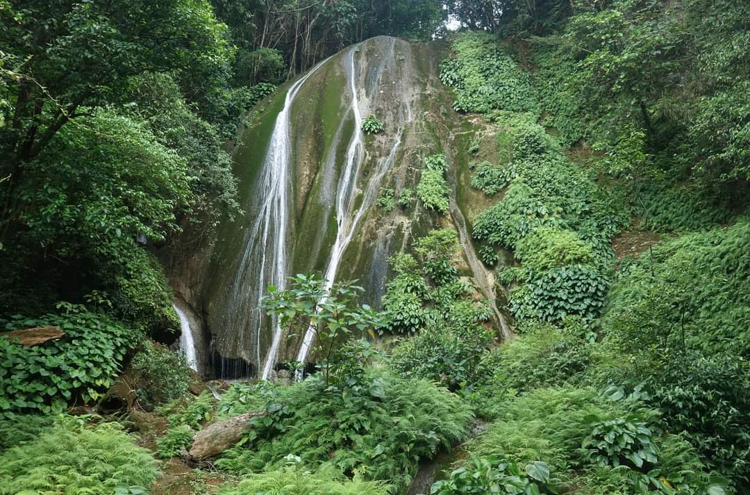
We stopped at a mountain cliff beside the river that was starting to swell. The cliff was festooned with epiphytic vegetation, vines and taro-like plants called bilagot (aba ti bantay). From that roughly estimated 100-meter cliff, a waterfalls plummets down at a 90-degree angle horizontal plunge before joining a small tributary of the Palawig River. The volume of water is determined by the torrent of rainy season but lucky enough that we have witnessed a world of wonder - though not in its most elegant, most voluminous form - the Salipawan Falls, as named by the very few locals who have reached this unknown point of vastness deep into the Sierra Madre.

A small portion of Salipawan Falls in its drier condition, among the tallest in Cagayan

Salipawan Falls is technically uncharted. Remote and sheltered. Not known and unpromoted even to and by the tourism and travel agencies. That is because of its sheer distance from the national highway reference and the perils of its inaccessibility for the faint-hearted. But I believe among the 75 waterfalls I conquered so far, this is probably the tallest known waterfalls in Cagayan, at least yet, as we still continue to prowl the bulk of the stupendous mountains of Sierra Madre in search for hidden allures such as this discovery.

The Palawig River transversing the length of the Sierra Madre evokes that of the Amazon in South America

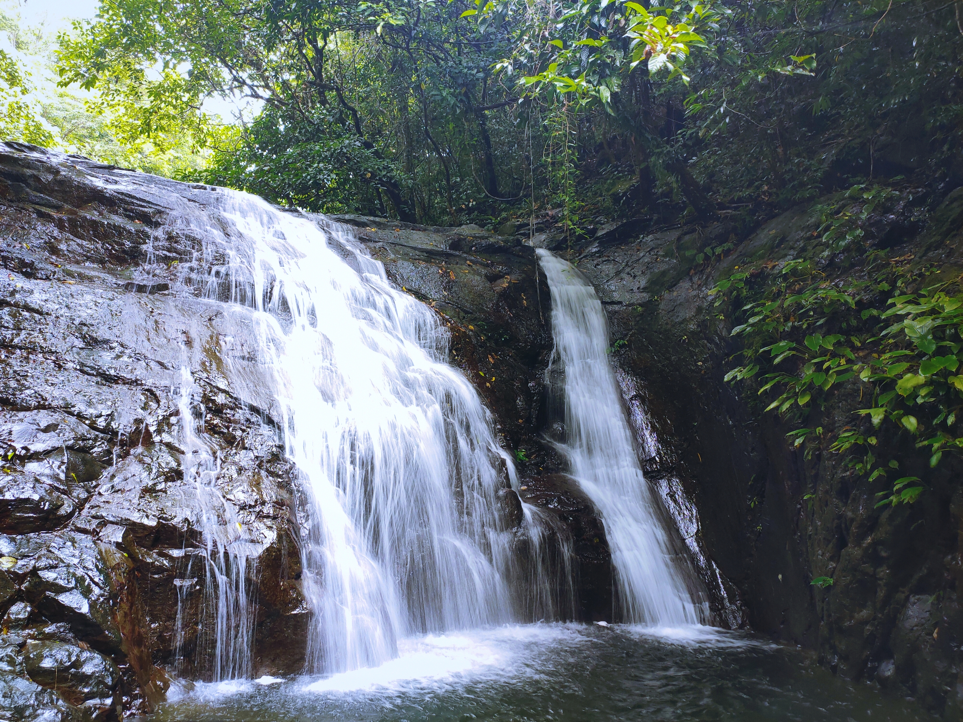
Our visit to Salipawan Falls may have been drier as it is now compared to its real form when waters are into its most hulking, substantial flow rate, but it remains as lovely and becomes an instant sensation as we firmly establish its fame as a realm of fabulous and fascinating. The more accesible and LGU-promoted Buwacag Falls may have robbed Salipawan Falls of the fame and glory it deserve, but it does not indeed lessened its value as a gem and giant centerpiece of the Palawig River that beautifies and adds drama to the entirety of the Sierra Madre. 

There are more plant species per square meter in a tropical rainforest than in any other biomes in the world 

Our discomfort of trekking the kilometric mountains for eight long hours - twelve if you include the initial hike to reach our first lay-over camp - was replaced by a peculiar sense of accomplishment. I felt it in my heart; the burning desire to write the journey-story of my life the way a photograph paints a thousand words that describe how we see life in the wild and into the great outdoors.

But I have to admit now, there's a part of me, in my heart that wants the rest of the entire Sierra Madre to remain unfound, forever, for all the humans to just pass by and all the planes and drones overhead never to land...

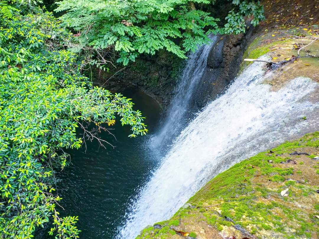
The Buwacag Falls, one of Santa Ana's tourist spot

And under the fading lights of the day in a world that seemed just made, I felt as I had in all of Santa Ana's Sierra Madre wild space, a witness to the beauty of creation's inspiration.

May you find value of nature and inspiration in life as you read this story of soon-to-be just faded memories. 


Full Video:

#IntoTheWildSeries #TheGreatOutdoors #PalawigRiver #ExploreCagayan #BeyondLasam #TropicalRainforest #EndlessFunCagayan #VisitCagayanPH #Cagayan #CagayanProvince

SICALAO, THE LAST ECOLOGICAL FRONTIER OF LASAM

FEATURING THE NANGARIBUAN FALLS

📌 Sicalao, Lasam, Cagayan

Video:

https://fb.watch/oWiHYYU1TK/?mibextid=Nif5oz

LASAM is dubbed as the rice granary of western Cagayan not just because of its vast farmlands but also because the municipality is one of the major sources of rice in Cagayan being transported to neighboring provinces in northern Luzon, Manila and Bulacan to where the agricultural products are milled and processed. Despite the immensity of its farmlands, no one would ever think that in the western portion of the town near the border of Flora, Apayao; in the heart of the thick tropical rainforest, there lies a glamour of nature - Sicalao, the last ecological frontier of Lasam.

The Nangaribuan Falls, one of the flagship waterfalls found in Sicalao, Lasam, Cagayan

Sicalao is the largest and remotest barangay of Lasam with a population of just 1,945 based from 2020 census. It occupies the largest remaining natural forestland in the municipality, home to several watersheds and is an extension and part of the so called Zinundungan River Valley, a valley system in the western portion of Cagayan to where this river originates before joining the enormous Cagayan River. Sicalao is endowed with incredibly rich natural resources and is part of the formidable Cordillera mountain range. Second only to Sierra Madre as the most extensive rainforest in the Philippines, the Cordilleras still has atleast 777,000 hectares of forestland as of 2015 records of Forestry Statistics of the Department of Environment and Natural Resources - Forest Management Bureau or DENR-FMB.

One spectacular portion of the Sicalao River, halfway going to the Nangaribuan Falls

The inner forests of Sicalao are wild, dense and can be said virgin to where we could still find first class timbers such as narra, molave, kamareg, ipil, marakape and maratiesa. The surroundings are verdant green. Its rocky mountains are towering cloaked with massive trees adorned with entanglement of vines and countless epiphytes. Different chants of birds, the gushing stream and drips from springs break the silence of the dizzying wilderness on the vicinity of Sicalao River that feeds the larger Zinundungan River, a tributary of Cagayan River, the country's longest.

The falls emanating from an uphill stream directly feeds the Sicalao River below before joining the Zinundungan River

Upon reaching the foothills of the mountains of Sicalao, the wildlife is unimaginable. It ranges from colorful birds, reptiles, innumerable insects and extraordinary flora. In the heart of this grand forestland hides one of Sicalao nature jewel - the Nangaribuan Falls. It is a 10-meter high waterfall fed by a stream uphill, creating a "twin" water curtain as the water flow is bisected by a rock on the brink of the fall. During summer however, the waterfall is relatively drier, resulting into just a single ribbon of water flow. It has a small plunge pool, about a human waist-deep and at least two meters at its widest. The cliff to where the water flows are dotted with "bilagot" plants (Schismatoglottis sp.) and the surrounding areas are dominated by hardy scrubs and bamboos or "bulo" (Schizostachyum sp.). The waterfall directly feeds the Sicalao River.

Reaching this waterfall is no easy feat. The river currents are powerful, the rocks are slippery and sharp, the established paths are thorny and muddy. Most of all, this natural monument is about 10 kilometers from the jump-off point, the iconic Sicalao Bridge. Its sheer distance to civilization and its hostile environment are its primary protection and defense from overdevelopment, abuse and extreme "humanization".

Distance and the wildness of the river are the primary defenses of Nangaribuan waterfall from imminent abuse

The rocks are gargantuan of different geometries. One of which is the famous globular rock called "nagbukel a bato" found almost halfway into the Nangaribuan waterfall. It is where most of the hikers initially rest because of the spectacular sights of the environ to behold. Some rocks are grayish, black or liver-colored; some however are white limestone origin. On the banks of the turbulent stream are groves of fiddlehead ferns growing prodigiously under the shades of valiant reeds. Bracket fungi, edible or not, detritus feeders and insect larvae find refuge on rotting logs resting into oblivion under the canopies as they enrich the forest floor to support myriad of life forms upon decay.

The nomadic Aetas in the forest were the first to discover the known waterfalls in Sicalao

The stream water is crystal clear, immaculately clean and relaxing cold. On its banks, fresh spring water oozes uninterruptedly and is potable. Its alkalinity is supposed to kill harmful pathogens. With the water's unbelievable clarity, small fishes, crustaceans and shellfish can be seen thriving in the water. Occasionally, the spectacle of a dazzling kingfisher precariously diving through the glass-clear water to catch its meal evokes a dramatic scene of nature unparalleled with what you could see in the outside world.

Upon reaching the Nangaribuan waterfall, taking a cool splash is persuasive. The coolness of the water is unwinding and destressing. It rids out the anxiety and lethargy as the mighty gravitational flow pampers your tired muscles. It revitalizes your blood flow and recharges your mind, body and soul with that unforgettable communion with nature. With the fast pace throbbing of life in the city and the problems that you are carrying all the days of your life, truly that nature is the best medicine for serenity.

Truly nature is the best medicine for serenity 

The sun already painted a gaudy yellow in the sky when we packed our stuffs. The once blue sky turned ash, signifying the approach of darkness. On our way, we started to hear the merriment of cicadas and crickets. We left nothing but footprints, we killed nothing but time and we brought nothing but memories of our remarkable travel to rediscover and take pride of the hidden allure of nature in Sicalao, the ecological face of Lasam tucked between the folds of the hemline of the Cordilleras.

While Sicalao promises a brighter potential to be a rising ecological tourism zone, this last frontier is still not fully discovered as much of its inner wilderness is still sever of human touch even to those nomadic Aetas who reside deep into the jungles of Sicalao.

The wildlife of Sicalao is unimaginable from reptiles, birds, bats, plants and countless insects

Indeed, Sicalao is a natural heritage; an ecological richness. There, hides a treasure chest of nature wonders yet to be discovered and that discovery with an ounce of thirst for the great outdoors needed patience, courage and passion to know more what lies beneath what is only palpable to most people.

Just like the province of Palawan as the last ecological frontier of the Philippines, it is now safe to say that the same can be said to Sicalao as the last ecological frontier of Lasam: despite of its prominence and excellence more in its agricultural aspect than in its ecological regards. It is certain then that the key to its protection is in the Lasameños' hands so as to immortalize its true stance as the last ecological frontier of Lasam.

Because the sad reality is that, we did not inherit this land from our forefathers but absolutely we borrowed it from our grand children and it warrants a return without damage and abuse as a result of our inherent stupidity.

A testimony of how rich the ecological frontier of Sicalao is.

#ExploreLasam #IntoTheWildSeries #SicalaoLasam #EndlessFunCagayan #YourIslandsAndValleyOfFUN #VisitCagayanPH #Cagayan #CagayanProvince