Friday, September 9, 2022

SANTA PRAXEDES: AN ANOMALY OF NATURE

πŸ“Œ Likid Falls, Sicul, Santa Praxedes, Cagayan

https://youtu.be/Hxy9hW3Ckps

PROLOGUE:" So lovely, must have been gazed upon by angels in heaven on their flight".

The upper part of Likid Falls

As I took a deep breath with the fern-scented saturated air of the wild tropical rainforest, I sighted a couple of bird pecking through a barely ripened water fig (tebbeg) donned with tangling vines and other epiphytes (lanut). So flamboyant as they were that I was startled by their sheer beauty, captivated by their colorful beaks and plumage, illuminated by the morning sun's rays that added drama to the spectacular view.

The dense jungles of Santa Praxedes town

Before my sanity has backed into normal and hurriedly prompted me to peek into my camera lens, the birds panicked as they were distracted by the sound of splashing waters created as I waded against the stream's rapid current . They frantically flew out of sight, engulfed by the unending vastness of the impenetrable thickets and tangled mass of the tropical vegetation of the Cordilleras.

Exactly, that I was in the geographical north of the formidable Cordillera mountian range extending from Bangui and Pagudpud, Ilocos Norte eastward to Sta. Praxedes and Claveria, Cagayan.

Few know that some parts of Cagayan touch the hemlines of the Cordilleras. 

Sta. Praxedes, the geographic north of the Cordilleras

At the point where this tiny speck of serenity confined deep within the jungle to where I wandered was in Sicul, Santa Praxedes in Cagayan, the province where adventures appear to never end.

And if you have not looked at Cagayan, particularly in the seemingly sleepy and not-so-bustling town of Santa Praxedes lately, then look again...

Santa Praxedes is an extreme northern Luzon anomaly of nature, a relatively peaceful, sparsely populated municipality located northwest of Cagayan province. Golden sand and white pebble beaches tucked within tranquil coves give way to a rugged forested interior; some more than half of the land area is still covered in forests, with its parts which are among the richest and most diverse on Earth.

Just one of the several tropical beach coves of Sta. Praxedes

In fact, the scientific journal "Frontiers of Biogeography" concluded that the island of Luzon is the most biodiverse on the planet.

The rainforest of Santa Praxedes is virtually part of the massive and life-teeming Kalbario-Patapat Protected Area Natural Park, a key biodiversity (KBA) and an important bird area (IBA) declared by the DENR under the NIPAS or the New Integrated Protected Areas Systems.

Much of the protected area however are located primarily in the towns of Adams and Pagudpud, Ilocos Norte with buffer zones designated in Sta Praxedes and Claveria southern grids both in Cagayan.

The emerald basin of the Likid Falls

The sheer totality of the natural assets within these zones including known species of high concern (Luzon endemic frog, horseshoe bat, flame breasted fruit dove, whiskered pita, green faced parrot finch etc.) as well as animal and plant forms yet to be discovered, is incalculably large. This KBA is home to more than a dozen of different fern species endemic to the country, not found anywhere else.

On that fine July morning, our team paid a courtesy visit to the town hall of the municipality of Sta. Praxedes prior to our excursion to enchantment.

The municipality's center of governance

Our destination was mapped to Likid Falls in the far flung village of Sicul, about 8 kilometers from the town hall. The road is less traveled. Dusty, narrow, bumpy and hot as we hiked through screes on dried stream beds, devoid of tall vegetation.

Still far from the shady forest floor, nearby we cut a broad palm leaf called "labig" and transformed it into a sun shade covering our delicate heads. 

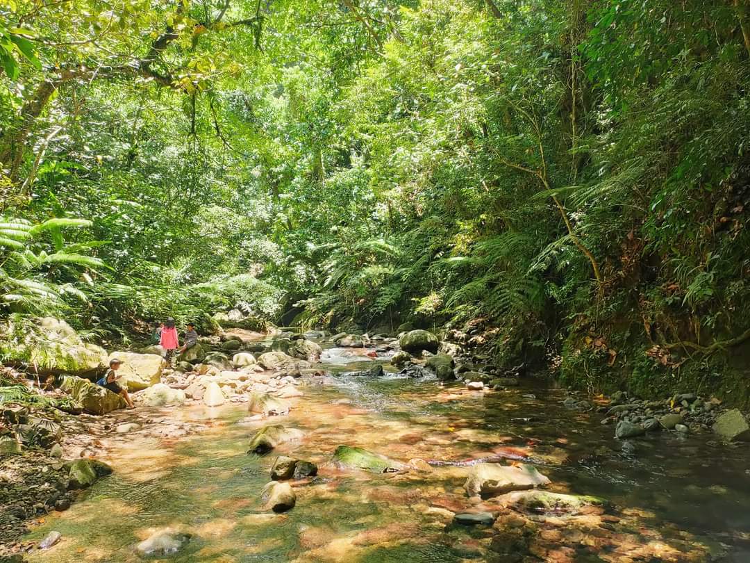
Our approach to a small stream now signified our coveted adventure under the enormous tropical rainforest. Sicul is rich in Earth's rarest commodity; even rarer than diamonds- tropical forests little touched by humans.

Upstream along the way going to Likid Falls

Clicking for a series of striking photos of the understory and canopy, I shot an indescribable extraordinary biological richness residing in the trackless rainforests, the remote mountains and the glass-clear stream waters.

I was blown away with the sounds of nature along the river lined with supermassive tree trunks and scrubs dominated by creeping vines; the caw of a kingfisher (salaksak) scanning the stream for food, the song of a sunbird (sawsaw-it) perching on a raintree (akasia) branch, the gushing murmur of the river flow or the sleep-inducing chit chats of the cicadas (kuliglig).

Glass-clear stream waters rich in prawns

It was already noon. Broad daylight. We were still far to our destination- the brilliant and splashy Likid Falls waiting for us. Our excitement has been halted by thirst and so together with our team, we laid for a couple of minutes for a gasp of air and a sip of water. Not so far, we noticed a lonesome hive, probably that of a bumble bee or a yellow jacket wasp. It was so fascinating; the insect gathering debris and constructing its abode.

Indescribable serenity

Through the silence that brought my heartbeats to the ears, I was beginning to hear the faraway rhythm of rapids or swooshing waters, like a sound that drifts into a dream. Strenghtened by the air of the surrounding verdant greeneries, we continued to thread the river, heading to our aimed target. The shallows are rich in thumb-sized forest river prawns and fishes.

The landscapes, at any angle were so breath-taking you will be forgiven for thinking you are really existing in the land that has been created before time.

So lovely, must have been gazed by angels in heaven on their flight

After an enduring, not so walk-in-the park journey, we have reached our bingo- the serene and lovely first tier of Likid Falls, all for the first time except for our kid local guides who, accordingly have been here for the third time around.

The first and lower tier of Likid Falls

I was astonished with how the water plummets, up from 10 feet high cliff into a bluish-green gaping hole below with the same depth creating a deafening sound of gush that is pleasant to the ears. The depression is also fed by constantly raining waters that ooze from the rocky wall that surrounds it about 50 feet high.

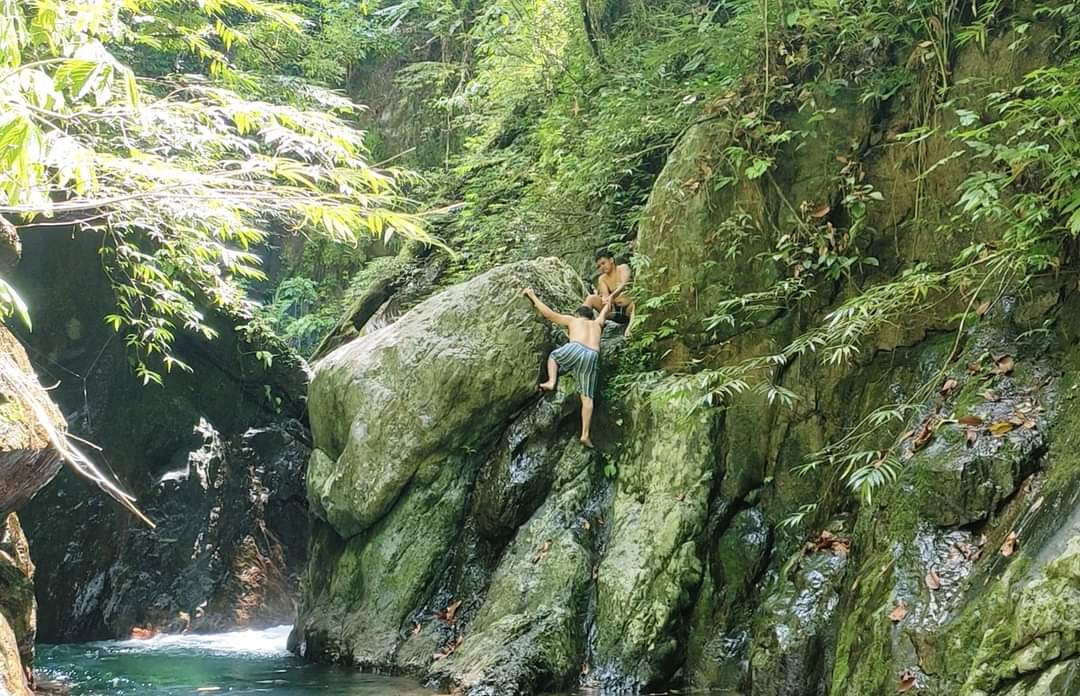
Jumping below from that pinnacle is so euphoric and adrenaline-rushing only the intrepid might dare to try.

Cliff-jumping in Likid Falls

Truly, scenes so lovely, must have been gazed upon by angels in heaven on their flight.

It was like a fairy tale came true; that of a heaven placed on earth.

The falls embraces a wealth of pristine waters and its vicinity harbors wildlife lurking inconspicuously up and below.

A small speck of tranquility in the heart of the tropical rainforest 

So clean and clear directly seeping out from a crevice, we tapped our tumblers into the sprouting water and wetted our parched throats.

Not far from the first tier, we crossed through a more-than-human deep karst water to reach the colossal rock where the second tier of the Likid Falls is hidden.

You have to climb and get pass through that rock ledge to have a glimpse of that jaw-dropping nature wonder. The feat was not easy however. The rocks are constantly wet and slippery. There were hardly any rough surfaces to cling on, there were no protrusions to hold on, there were no ropes to grip into and the rocks below it are sharp deep underwater.

The dangers of trekking the forest going to Likid Falls

Perhaps it was the adventure on the trail rather than the comfort in the final destination that still beckons us to roam into the great outdoors. 

There on the top, the magnificence of Likid Falls mystified us once more right infront of our eyes; the others stunned and explicitly bewildered by the massive volume of water falling from a 20-foot high cliff side. As it plummeted to its deep aquamarine basin, mists blown by the wind drenched our faces into our eagerness for a quick dip.

Upper Likid Falls: mystifyingly beautiful 

Thriving undisturbed on the cliffs are taro-like plants called "bilagot", an edible local food.

Different ferns, bromeliads and water plants outlined the surrounding rocky area and all we could see to the horizon, in every direction, was unbroken canopy on its thousand shades of green and through it, a thin slash of the immaculate white river.

But Likid Falls beauty has faraway qualities that can change to a devastation on close scrutiny: The long grass blades and certain thorny vines will snag and prick, the slippery and sharp stones cut the unprotected feet, the emerald green but clear waters are deep and there maybe fangs, stingers and itchy hairs I hope I would never encounter.

Different ferns, bromeliads and water plants outlined the forest 

On our way back to reality, my brief detachment from the world to explore the paths less traveled brought peace and contentment in my heart. My intense desire to feed the urge of roaming the great outdoors has kept me alive and view the wild world through the lens of a deep, unwavering adventures into its most subtle, most appreciable form of beauty.

I still recall when I first felt the allure of Santa Praxedes through my getaways in one summer at Mingay beach, a tiny speck of tranquility tucked between mountains and the seas.

And I say it again.

If you have not looked at Cagayan particularly in Santa Praxedes lately, then look again. ™️

"Perhaps it was the adventure on the trail rather than the comfort in the final destination that still beckons us to roam into the great outdoors"

https://m.facebook.com/story.php?story_fbid=pfbid0oaS4VG8S9cZ1DrALRoBP5JXmSZKqFtbxSg1sCSZbAwb88BCwgjePcaHxJ9M3MeMtl&id=100007283687906

Supplemental posts:

https://m.facebook.com/story.php?story_fbid=3152570194995739&id=100007283687906

https://m.facebook.com/story.php?story_fbid=3075876772665082&id=100007283687906

https://m.facebook.com/story.php?story_fbid=3034457923473634&id=100007283687906

#TheGreatOutdoors #IntoTheWildSeries #ExploreCagayan #BeyondLasam #TropicalRainforest

Sunday, September 4, 2022

THE TROPICAL REGIME OF SICALAO CAVES

 PRELUDE:

Lasam is a land-locked municipality of Cagayan in the eastern hemline of the formidable Cordillera mountains with Sicalao as the largest barangay...

The interior of one of the many chambers of Isus Cave

THE TROPICAL REGIME OF SICALAO CAVES

πŸ“Œ Isus Cave², Sicalao, Lasam, Cagayan

Cloaked with magnificent evergreen forests growing prodigiously the entire year of a well-balanced rain-sun barrage, Sicalao has enjoyed the bounty of a tropical rainforest endowed with a treasury of extensive wildlife with timeless confidence.

Considered as the last ecological frontier of Lasam, Sicalao hosts wonders of extraordinary features almost strange, unheard-of to the oblivious: A diversified flora and fauna, a volcanic mountain and karsts, calcareous and limestone hills, highest peaks and point, underground river still barely probed, and tunneling network of caves only the undauntable adventurers would dare to conquer.

The thick rainforests of Sicalao

With the Zinundungan River meandering right at the center of it, fed by the Sicalao stream emanating deep into its massive forested interior, it sustains the entire valley of the Zinundungan and the enormous rice and crop fields of Lasam.

The tropical regime of alternating wet and dry gives way to the more complicated shadings beneath the forest floor of Sicalao, in return supporting myriad of species of animals and plant forms.

Super-massive tree buttress in the tropics

The limestones are wet, dominated by lichens (lumot) and alluring epiphytes in multifold of morphology almost impossible to resist uprooting.

The thickness of fallen leaves from valuable trees such as marakape (dipterocarpaceae spp.), maratiesa, magallayaw, narra (pterocarpus), labting and lowland bushes sustains the soil by its richness in organic matter that eventually harbors incalculable number of individual species from scorpions (manggagama), termites (anay), stinging ants (ammimisay), as well as vertebrates such as forest frogs (ampipilat, polypedates), monkeys (sunggo, macaque), snakes, green crested lizards (bannagaw), varanus (banias), wild boar (alingo), birds and possibly cloud rats (bao ti bantay).

The fruit of "marakape" tree

Epiphytic plants (aruy-oy) hanging gracefully among branches are scenes to behold. Huge tree trunks, butresses as gargantuan as a truck are magical, the experience seems like a time travel into the Amazonian rainforest of South American realm.

Up high on the slopes of a limestone mountain are numerous cave entrances, barely attained, some of which still left unexplored. These narrow tubes, each that leads to a larger, cathedral domes are oppressive, unfriendly, guarded by scorpions and monstrous ants with mega killing-jaws and stinger on their rear.

Cathedral-dome of Isus Cave in Sicalao

It is not something a mediocre traveler would wish to have in his bucket list.

But it's our peculiar sense of accomplishment upon triumph that drives us to continually strive for our desire of interests.

Stinging, creepy and wild.

These caves may have been pacified by their nearness to a local Agta community near the Sicalao creek but unpredictable and powerful, the Sicalao caves assure that no wilderness- left in its natural state, is ever tamed.

The external of the cave dominated by lichens

And taming the caves somehow requires a Tarzan-stamina, adaptive into arboreal living on the viny landscape. An almost 90-degree slope cliff face awaits every intrepid spelunkers, crumbled rocks pose perils upon a misstep and the menace of deadly fangs, stingers and hypersensitive plant trichomes and thorns is lurking inconspicuously, cryptically hidden among the dead leaves or beneath disintegrating logs.

It was here on Isus Cave in Sicalao that I began to appreciate the intricacies of landforms and the biodiversity of the municipality of Lasam.

A Philippine fantail making-up the biodiversity of Lasam

While Sicalao could and might still have a dozen of caves, a couple has fascinated our team for their bizarre characteristics: One of which, the Isus, has series of small tunnels and orifices leading to one another.

Caves in karst landscapes are splendid due to their grand interiors well decorated with stalactites, stalagmites and other speleotherms. This cave has more swiftlets and swallows (sallapingaw) than there are bats (panniki or kurarapnit) which we normally know it should be these flying mammals' prime dominion.

A swiftlet in its edible nest

Contrastingly, the nearby Oning cave might be the most dangerous of all known caves in the municipality because of its squeezingly tight opening, vertical descent and a distressing rapid flowing stream inside of unknown depth.

One of the creepy entrances of the Isus Cave 

Liocheles scorpion found in the rainforests of Sicalao

Our team failed to investigate this frightening but startling beacon of the last ecological frontier for safety reasons- at least for now.

But our desire for curiousity is still paramount than the dangers our explorations could offer; it will not last for long before our return into the wild, continually exploring the great outdoors.

Mang Jose, an Agta tourist guide

https://m.facebook.com/story.php?story_fbid=3158995247686567&id=100007283687906

Supplemental:

https://m.facebook.com/story.php?story_fbid=2798056677113761&id=100007283687906

https://m.facebook.com/story.php?story_fbid=2759065644346198&id=100007283687906

#IntoTheWildSeries #TheGreatOutdoors #IsusCave #OningCave #TropicalRainforest

Thursday, September 1, 2022

ZIVAC HOSTS TRAINING FOR BANTAY-GUBAT DEPUTIZATION

 ZIVAC HOSTS TRAINING FOR BANTAY-GUBAT DEPUTIZATION

PERU, LASAM|

With the prime purpose of conserving, sustaining and protecting the environment and natural resources of the entire Zinundungan Valley and the rest of the forestland of Lasam, the Zinundungan Valley Agriculture Cooperative (ZIVAC) spearheaded a 2-day training for the deputization of "bantay-gubat" volunteers also known as the designated Deputy Environment and Natural Resources Officers (DENRO) in coordination with the Department of Environment and Natural Resources (DENR) and with the support from the Kaakibat Civicom (KCIL-141) and the Local Government Unit on August 30-31, 2022.

Peru Lake, Lasam, Cagayan

The training and orientation focused on the forestry and environmental laws and the rules and regulations governing several mandates such as the Chainsaw Act, Wildlife Act and the New Integrated Protected Areas System or NIPAS Act and Mining Act.

Attended by more than 60 participants and volunteers from different sectors in government and in the society including the Agtas (IPs), the aim of the training is to delegate these volunteers to be the DENR-recognized forestland watchers and protectors in their designated domains equipped with the proper knowledge and procedures in effect to carry out their roles.

Bantay-Gubat Volunteers

In a short speech by municipal Mayor Dandex Agatep, he expressed his grief over his awareness of the massive but silent forest destruction and abuse in Lasam. Emphasizing the importance of the training, the mayor said that he is in full support of the funding of this endeavor and its successive undertakings because according to him, the forests belong to our children and to the future generations to come.

Mr. Joselito Razon, CENRO OIC and one of the speakers also called out not only the volunteers but all the people to be vigilant in their surroundings for unscrupulous and unpermitted cutting of trees.

He asserted that the environmental laws won't spare anyone in violation even if politicians and police officers are involved.

Massive forest destruction

"But remember, cutting, possessing and transporting of trees are permitted provided that you fulfill all the necessary permits", the director however clarified.

About 30 DENROs (officers) and 20 bantay-gubat volunteers (Agtas) are expected to be deputized by the DENR after the said training.

Lasam is a 3rd class municipality with a total land area of 223,000 hectares. Natural forests cover an extent of 44% of the total land area much of those are located in barangay Sicalao, Viga, Peru and Cabatacan areas collectively known as the "forest heartland of Lasam".

A brahminy kite raptor found in Lasam

Leading the way to a healthier environment 

https://m.facebook.com/story.php?story_fbid=pfbid0n81VEFKe8AQ5gwLcUXYoFeB74CF8zGUjTeCGZFM6egoYgbcG7a1fB5CDeJkAttUEl&id=100057543074032

#ExploreLasam #IntoTheWild #BantayGubat

Monday, April 25, 2022

MINGAY, STA. PRAXEDES: AN ESCAPE TO THE EXTRAORDINARY

MINGAY, STA. PRAXEDES: AN ESCAPE TO THE EXTRAORDINARY 
By Saniboy Pacursa

From the immense northern seas, a cooling breeze that negates the heat of the scorching broad summer sun rolls in, rustling the huge, elongated leaves of beach almond trees (lugo) that lined the serene beachfront. Sitting on a log under the shade, I look out on a seascape of aquamarine, turquoise blue colors. At anchor on a tiny bay hugging into the hemline of the northern Cordilleras before me, are several fishing boats gleaming painted yellow in the sun on a backdrop of the startling blue sea. 

A curving panorama of pale golden sand spattered with colorful seashells and coralline fragments defines the entirety of the semicircular bay. A dense, tropical growth of a verdant greenery of enormous trees blankets the surrounding hills and mountains set back opposite from the beach. I am in a traveler and backpacker’s paradise that where dreams are made of. I am in every intrepid’s destination wish list in this tiny, sunny speck of tranquility.

A traveler's paradise

This still unknown, unheard-of paradise is in Mingay Beach, Sta. Praxedes town in Cagayan, the northernmost province in the mainland Luzon Island tucked between the Sierra Madre mountain range in the east and the Cordillera mountain range in the west. I will be a little bit bias when I describe Cagayan as the most picturesque province in northern Luzon, Philippines. I have come to several places in Cagayan, but this time in the municipality of Sta. Praxedes on an excursion into the non-celebrated, not so famous destination, the mediocre will snub; until I would consider the place as one of the most beautiful places in the province I’ve been into.

Mingay Beach

Cagayan abounds in such settings - from lush, wild rivers, vast grassy plains, magnific caves, lofty virgin mountains to wild coastal realms. But spots like Mingay, is unusually special. As for most others who know the saga of Robinson Crusoe in an uninhabited island off South American western coast, Mingay represents a place in the northern coast to kick off your shoes for a real life fantasy of the same saga or Tom Hank’s “Cast Away” survival adventure.

Time is too slow in Mingay but my settlement for three days in the bay was perfected in a spectacular way where the quickest pace of the day was having indulged in a beach stroll. At sunrise, a littoral hill commands the picture-perfect view of the arching bay of the pale golden sand encircled by the massive part of the Kalbario-Patapat Protected Rainforest, a key biodiversity area assessed by the International Union for Conservation of nature or IUCN.

A littoral hill at Mingay Beach

At sunset, an equally fascinating bay, the Mingay A Bassit Beach (Little Mingay) over that littoral hill westward can exert a sort of pull, a beacon of excitement. The hill, located perfectly between the two bays serves as a giant sentinel, offering two-sided, left and right panoramic view of the semicircular bays. There is no permanent population in Mingay. No roads, no cars. No Wi-Fi, no telephones. No stores, no inns. No electricity, no night life.

Mingay A Bassit as viewed on a hill top

On Mingay, the only way to get there is through a boat from the nearby Claveria town or by hiking the precipitous up and down terrains of the Kalbario-Patapat Protected Rainforest several kilometers from the Pan-Philippine Highway. Not even ordinary locals brave going to or staying at laidback Mingay for so long. Some people, mostly small fisher folks come here not to get -away for an adventure but to fish for their own consumption; if there are some that remains, their catch are sold to the adjacent town of Claveria, in Taggat Lagoon.

Part of the Kalbario-Patapat Rainforest

Come night, there are no lights except from the adventurers’ and some fishermen’s torches. Night is the best time for the fishermen to set their nets asea, bringing back octopuses, wrasses (mulmul), drummers (angrat), parrotfish, goatfish (balaki) or the rare unicorn fish (papaget) at dawn time. During my visit, there were no other group of people except my team of four - two of them, local guides. There were no sounds other than those from nature – the rush of winds through the trees, the songs of nocturnal birds and insects and the harsh gush of the surf in its perpetual barrage of waves, striking the side of the Simmapatos rock formation not too far from the spot where we set our camping tents. I dined there on a leaf plate for experience, on seafood previously pulled hours earlier from the near shoals and coral reef-rich waters of Mingay; a bounty of ar-arusip (sea grapes), pumapana (sea urchins) and a delectable grilled mulmul (parrot fish).

The bounty of Mingay Sea

The magical lights from the galactic Milky Way bathed the entire beach before I closed my tent for a peaceful night’s rest. Paradise as it is, Mingay Beach beacons the travelers with the promise of escape to the extraordinary.

On the first glimpse of the morning, my journey on the stretch of Mingay revealed a landscape of exotic and at once familiar. To me, its wild shores and limpid waters remind me of the equally beautiful island of Calayan. Its colossal rock formations and coral reefs teeming with life evoke those in Camiguin de Babuyanes Island. Its green palette mountains resemble the Sierra Madre of Sta. Ana, Cagayan and the Palaui Island. It’s the juxtaposition of these different features makes Sta. Praxedes so exotic, yet alluring.

A rock formation at Mingay Sea

We landed first on the majestic Burbursayok Falls where it plummets down from the rainforest rocky cape directly to the Babuyan channel, a body of water separating Luzon mainland from the Babuyan Group of Islands in the north. It can only be reached by boating or rafting, not that far from Mingay Beach. The basin of the falls is very clear with traces of white sand from the bottom. As we led our way to the next destination, several rock formations and caverns greeted our sight with such nature sculptures locally named as Simmimbaan, Immuki, Abut ti Buwaya, Immugsa, Simmapatos, Tallo-Ulo, Simmunggo and many more others owing much to the description of their forms as seen by the local fishermen.

Wild shores of Sta. Praxedes

We briefly anchored in a swimming pool-clear waters protected by the surrounding reefs only to be mystified by the high-rising Bilbilagot Falls free-falling to the sea. With nearly eighty waterfalls in the country I photographed and personally documented, Bilbilagot is the tallest and possibly also the highest known waterfalls in Cagayan. I donned a snorkeling gear and dived on the shallow natural aquarium near the waterfalls. I could see fishes of extravagant colors and seemingly limitless variety of corals in bizarre shapes, swaying from them were edible sea weeds.
With my team, we carefully pulled some dangerous long-spined sea urchins and conch shells (pusa-pusa) reserved for another dinner. But one sight I will always remember was the spectacle of several men collecting gamet, a type of expensive but palatable sea weeds clinging from the slippery, massive rocks extending into the sea that are constantly torpedoed by the torrential sea waves of the China Sea-Pacific ocean junction.

Bilbilagot Falls

Sta. Praxedes is a town of beautiful sheltered coves, arguably the most in the entire province with about a dozen or more if we include those unnamed ones. Of those, there are eight notable beach coves namely the Salsalaysay, Immugsa, Mingay (Dakkel and Bassit), Puwak, Nanaplaan and Kimmansir. Each cove has its own, unique characteristic of tranquility, clear waters and eye-catching beaches bounded by massive cliffs saturated with rainforest and thick vegetation. But Kimmansir Beach is the most stunning, most bewitching and most enthralling of them all yet, also the farthest to reach.

A Praxedenian shimmering jewel, the Kimmansir Beach offers the enchantment of turquoise blue waters, murmuring surf and the peculiar immaculate white, uniformly sized quail egg-shaped stones on its beach embedded on a pure white, coralline seashore. As we approached the beach from a small boat, Kimmansir sparkled and was beaming as the white beach met the sun rays of the morning. There were no other visitors except our team of four, plus our hired boat man. We have literally possessed the beach for hours.

Ivory white Kimmansir Beach

It is a landscape that captivates at first glance. It has enchanted ever since just the fisher folks and some locals for decades because it remained concealed, hidden, out from the outside world until the boom of ecotourism industry. And for those fortunate enough to travel here, Kimmansir still charms them, one thing it has done for many decades since its first visitors experienced the same bewilderment.

But for the seasoned adventurers, it’s not the cozy hotels and lavish night life that impress them in the places they go. For me, the enchantment of the Mingay and the rest of Sta. Praxedes would come into its both rugged and untroubled coasts, magnificent coves, rich tropical rainforest and laidback life that sure thing will bring you an adventure to the unusual, an escape to the extraordinary. ©️

Wednesday, March 23, 2022

THE VILLAGE OF MY DREAMS

 THE VILLAGE OF MY DREAMS

Walking through the muds,

I dreamed of someday hopping on the islands. .

Riding on a cow,

I dreamed of someday driving on a wheel.

Lunching by the fields,

I dreamed of someday eating in a buffet.

Munching on cassava,

I dreamed of someday licking an ice cream.

Playing in the dust,

I dreamed of someday chilling in a beach.

Seeing just the plains,

I dreamed of someday conquering the peaks.

Living in the village, 

I dreamed of someday roaming in a city.

But I will never leave my village, the village where the seeds of my dreams were first sown. 

Shot at Mingay Beach, Sta. Praxedes


Wednesday, March 16, 2022

CAMIGUIN DE BABUYANES: The Paradise Barely Attained

Camiguin de Babuyanes Island:

THE PARADISE BARELY ATTAINED

By Saniboy Pacursa, RPh.

In contrast to the fast-paced and stressful routines in the ever-crowded cities, let's shift and focus our getaway to the north of mainland Luzon, the Camiguin de Babuyanes Island.

Even though the Babuyanes is still aloof to the outside world, fairly oblivious to the human presence, it remains special, beckoning every traveler with the enchantment of the remote, the isolated and the barely attainable.

Camiguin de Babuyanes Island, under the jurisdiction of the municipality of Calayan, Cagayan, lies north of Aparri in Babuyan Channel, south of Batanes in Balintang Channel, between the immense Pacific Ocean on the east and the tensioned South China Sea, westward.

The perpetual barrage of waves between these massive bodies of water provides perfect breeding grounds for the multi-ton humpback whales, dolphins, porpoises and other big games.

And so dubbed as "the playground of the giants", the Camiguin de Babuyanes, its nearby islands and islets are blessed with a wealth of marine biodiversity, pristine and crystalline white beaches, swimming pool-clear shallows and reefs still away from the immediate reach of the modern world of today.


Camiguin de Babuyanes, the playground of the giants.

Camiguin de Babuyanes Island is a remote realm of a tropical paradise: picturesque volcanoes, teeming marine sanctuaries, rugged and idyll coasts, dense forests, dominating wilderness, bewitching waterfalls- all in one place. Such a spectrum of environment holds a matching wealth of natural treasures. After seeing such wonders, you'll understand why the people of Camiguin assure departing visitors that they will return.

With that, "Camiguin" turned out to be derived from the English phrase, "come again".

You can stop the time in this island and you'll never run out of it in this seemingly bleak, volcanic Camiguin de Babuyanes.

Inside one of the craters of Mt. Camiguin de Babuyanes Volcano.

The Mount Camiguin Volcano that serves as the island's gargantuan centerpiece is clearly visible from Luzon landmass. Witnessing a world of wonder over the 623-meter high summit, a climber can gaze the sunrise and get the panorama of the island's entirety. The numerous craters on the volcano's slope provide the intrepid an experience of close up view of boiling chambers, misting fumaroles and spewing vents. Another volcano nearby, the Smith volcano is as equally intriguing to trek as the Mt. Camiguin Volcano.

West of the Camiguin Island is the uninhabited tiny island of Pamoctan where campers come to learn the act of survival of the fittest. Featuring a central, freshwater lake surrounded by tussocks and green pastures for grazing cattle, the tranquility of its waters will enwrap strollers to circumnavigate the island's white beach and rocky, bouldered shores and cliffs.

Pamoctan Island white sand and boulder beach.

Not far from the Pamoctan Island is the drop-dead rock island of Pinon, an elongated, wedge-shaped islet crowned by huge boulders and scree, sashed with an expanse of green rolling pastures with thickets of bushes. Atop of its largest boulder offers the limpid perspective of the Mt. Camiguin Volcano, sometimes its lofty peak being drenched with the immaculate band of clouds.

The massive boulders of Pinon Island.
Very idyllic and serene.

The pellucid waters of Sapio beach embodies the richness of the Babuyanes marine life as urchins, shellfish, starfish, crustaceans and other extraordinary marine invertebrates seek refuge on its shallows and reefs.

Morning-stroll along its white beach southward and you'll find yourself awed in Naguilian beach whose snorkeling paradise is just a few meters away from the shore. Brain corals and giant clams abound unperturbed as colorful gobies and parrotfish graze among the corals.

Navigating eastward facing the Pacific Ocean, the outline of another volcano, the rocky Didicas, is clearly apparent as you visit the ravishing Nagparakapak Falls. This multicolored waterfalls got its name from the local, Iloco word "parakapak", which means the sound of water produced as it strikes the rocky ground.

The volcanic Nagparakapak Falls, the most colorful waterfalls in the universe.

The different hues are due to the volcanic minerals and lichens deposited on the surrounding areas and embedded among the rocks and cliff side. Volcanic as it is, a stretch of its beach contains fumaroles and vents that are constantly emitting plumes and sulfuric vapors making it the most peculiar beach and could be the only one of its kind in the country.

When reaching the Half-Sunken Donut Rock Formation , you may happen to race and play with pods of dolphins or witness the breaching of whales on the waters off Camiguin. The rock formation is colossal in an almost perfectly arch shape resembling a chocolate donut sprinkled with crushed almonds, dipped halfway unto the water.

The supermassive Donut Rock Formation in contrast with the gnat-size boat nearby.

Above a littoral hill nearby commands the vastness of the entire Donut Rock Formation with the backdrop of the immeasurable horizon of the Pacific. A rigger boat would be a gnat-size compared to the rock as seen from above the hill.

In addition to the portfolios presented, as alluring as such adventures may be, are still countless beauties uncharted, unpublished and barely reached from this remote, isolated island of Camiguin de Babuyanes.

You will never regret choosing the Babuyanes. My own travels have touched on just a few of Philippine island treasures but enjoying and experiencing the "cast-away" of Robinson Crusoe is a dream itinerary for me in this one of the most, if not the most scenic and peaceful locale I visited in the country yet so far.

This is Camiguin de Babuyanes Island, an embodiment of a true excursion to enchantment.©


Saturday, January 29, 2022

BAGI FALLS, SICALAO, LASAM, CAGAYAN

The adventure to Bagi Falls in Sicalao, Lasam, Cagayan.


https://m.facebook.com/story.php?story_fbid=394167169178049&id=100057543074032

Friday, December 24, 2021

THE LEGEND OF CAGAYAN RIVER

Theme:

“Cagayan River: looking back at our past, nurturing the present and looking forward to the future”.

Synopsis:

Once an ally, two brave leaders in the East and West of the province had been in conflict for the rich valley land until the formation of Cagayan River brought them together again into peace, united as one.

THE LEGEND OF CAGAYAN RIVER

Once upon a time in a massive, rich, fertile “tanap” or valley, north of the so called Luzonia Island, there was a sprawling and bustling village called “Kaagayan” which means “the place where our friends live”. Its root word “Agay” was the term used by the villagers to call friends. It was ruled by a kind, generous and brave leader named Apo Daya.

Kaagayan was bounded by the mighty Cordillera mountains in the west and the enormous Sierra Madre range in the east. The prosperity of the village owed to the abundance of rain, the natural fertility of the valley soil, the richness of the mountains and forests and the blessing of their “anito” or deity named Kabunian, the god of good harvest.

Whenever harvest seasons begun, the villagers offered Kabunian a portion of their produce called “atang” as a sign of thanksgiving. The people were helping each other and there were no misunderstanding among them. Kabunian, the all-powerful deity was very happy to see how grateful and kind the people of Kaagayan and thus, made their “apit” or harvest always bountiful.

As days, months and years passed by, the village became more industrialized and grew forth in population. Parts of the once vast fertile lands were converted into residential places. This led to the decrease in harvest, aggravated by ‘tikag” or severe drought brought about by El Nino phenomenon during those times. As a result, there was an impending strike of famine.

To address the persisting problem, Apo Daya designated another leader to help him manage the difficulties the whole village was facing.

“We needed another great leader to help us overcome this crisis”,

lamented Apo Daya and so the wise leader appointed the courageous and fearless Apo Laud his “makannawan” or right hand to guide and manage the Western valley front of Kaagayan. The Eastern valley front was left for Apo Daya to preside over. As two heads were better than one, the populous village of Kaagayan became more powerful and progressive again as they developed new means to increase their harvest yield and looked for other ways to compensate for their ever-increasing needs.

Many years had passed; there was again a population spurt. The once village of Kaagayan became what is known today as a province. And so, much of the land and mountains have been decimated and cleared to build houses and roads. Harvests were so scanty as the valley land could not anymore produce enough food for the growing number of people.

The only remaining huge fertile land was located on the central part of the province lying between the colossal mountain ranges of the Cordilleras and the Sierra Madre.

“Let’s divide the central valley”,

suggested by the bright Apo Daya and so the two leaders have bilaterally agreed to divide the remaining rich land into two equal portion. The Cordilleras and the western side became the realm of Apo Laud. The eastern portion facing the Sierra Madre became the domain of Apo Daya.

The Sierra Madre mountain range was producing more rain as it faced the Pacific Ocean and thus, keeping the Eastern Kaagayan produce more harvest than the western counterpart of the province which was a little drier. This made Apo Laud thought that he was tricked. And so there was a rift or “riri” between the two great leaders.

“We have to make something about it as we are not producing enough food for our people. We were fooled as we have received the less productive land”,

complained Apo Laud as he explained the problem to his people. There was now a feeling of vengeance and greed to the people of Western Kaagayan and so they begun stealing the harvest of the people in the East. Not only that, they have crossed the boundary and invaded Eastern Kaagayan to get parts of the more productive soil.

This infuriated the great leader Apo Daya and so he declared “gubat” or war against the West. The conflict lasted for more years and since then claimed so many lives into the detriment of both sides. Because of this, life in the province became harder for all the people to bear.

For some time, there was a truce between the two fronts and one of the “panglakayen” or great sagacious elders named Lakay Kasiriban advised Apo Daya.

 “Ask Kabunian for the needed help and so that peace shall ensure between his people, the once united, harmonious people of Kaagayan”,

the bearded wise elder told Apo Daya.

The brave leader agreed.

“Let us pray to the mighty Kabunian”, appealed by Apo Daya and so his people followed as advised. The people offered “atang”, knelt down and begun to pray.

Kabunian, the all-powerful deity was not happy about the rift between the people of Kaagayan whom he blessed with fertile land and good harvest.

And so in an instant, the sky darkened and the ground shook. The central valley cracked and ripped apart and there was a huge, long void. The crack was slowly filled with rainwater and springs oozed from the bottom of that deep rupture, persistent and long enough that the flowing water reached the end of the land into the north of Luzonia Island.

“This I made, a permanent partition from east to west and so rift between my people would not continue. I will keep the valley fertile, rich and productive though. This I say unto you my people, the waterway that will dampen your valley home and produce the largest food harvest in the entire land”,

Kabunian mightily said as his voice reached the land echoing in the entire valley. And so all of the sudden, an iconic “karayan” or river amid the vast Kaagayan Valley was already flowing leading northward to what is known today as the Babuyan channel.

And there was fear among the people witnessing in awe the enormous waterway meandering through amid the valley.

It was then that Apo Laud realized his mistakes and pleaded for the pardon of Kabunian.

The remorseful Apo Laud humbly conceded to their old great leader Apo Daya and so peace has been restored in the valley between the East and West of Kaagayan.

The two sides had now producing massive rice harvest and other major crops such as corn, peanuts and sugarcane, thanks to the great river that bisected the entire province in eastern and western half, irrigating both ways.

The river had gradually and strongly unified the two fronts of the east and west, known today as Districts 1 and 2 and so the province of Kaagayan later became “Cagayan” derived from “karayan” which would mean river; the river that brought fortune to the entire valley; the river that became the bloodline of the entire valley home of the people; the mighty river in Cagayan; none other than the Cagayan River.

Today, the people of Cagayan know the importance of the Cagayan River in their lives. It became a symbol of hope, unity and progress among the people. It is the life of the entire valley home that needs to be loved, protected and sustained as it played a major role in the development of the Cagayano’s rich culture in the past, at present and in the future days to come.©️

Winner, 2nd Place Cagayan Writing Competition 2021;

Entry by Lance Bennett Pacursa CariΓ±o of Lasam, Cagayan, coached by Sonnyboy Pacursa.